
Hampshire
Beschreibung
County in southern England. The South Downs, well known limestone hill area, is located in Hampshire. The coastline is of course good for hiking. And the New Forest is in Hampshire as well. Apart from the well known South Downs Way, the county has created a list of shorter trails.
Wanderwege Region
Links
Fakten
Berichte
Führer und Karten
Übernachtung
Organisationen
Reisebüros
GPS
Sonstiges
Bücher

The Book Depository
United Kingdom
United Kingdom
- Also available from:
- Stanfords, United Kingdom

Stanfords
United Kingdom
United Kingdom
- Eastbourne & Beachy Head - Newhaven, Seaford, Hailsham & Heathfield OS Explorer Active Map 123 (waterproof)
- Eastbourne & Beachy Head area of Sussex on a detailed topographic and GPS compatible map No. 123, waterproof version, from the Ordnance Survey’s 1:25,000 Explorer series. Coverage along the coast extends westwards from Pevensey and the Pevensey Levels to Newhaven, inland to Heathfield and Uckfield, and includes Birling Gap, the Seven Sisters... Read more

The Book Depository
United Kingdom
2018
United Kingdom
2018
- Fastpacking
- Multi-day running adventures: tips, stories and route ideas Read more

- Also available from:
- De Zwerver, Netherlands
- Stanfords, United Kingdom

De Zwerver
Netherlands
Netherlands

Stanfords
United Kingdom
United Kingdom
- Chichester, South Downs, Bognor Regis & Arundel OS Landranger Map 197 (paper)
- Chichester and Bognor Regis area, including the South Downs National Park and a section of the South Downs Way / E9 European Long-distance Path, on a paper version of map No. 197 from the Ordnance Survey’s Landranger series at 1:50,000, with contoured and GPS compatible topographic mapping plus tourist information.MOBILE DOWNLOADS: As well as... Read more

- Also available from:
- Stanfords, United Kingdom

Stanfords
United Kingdom
United Kingdom
- Aldershot, Guildford, Camberley & Haslemere OS Landranger Active Map 186 (waterproof)
- Aldershot and Guildford area, including the northern part of the South Downs National Park and a section of the North Downs Way / E2 European Long-distance Path, on a waterproof and tear-resistant OS Active version of map No. 186 from the Ordnance Survey’s Landranger series at 1:50,000, with contoured and GPS compatible topographic mapping plus... Read more

The Book Depository
United Kingdom
United Kingdom
- Also available from:
- De Zwerver, Netherlands
- Stanfords, United Kingdom

De Zwerver
Netherlands
Netherlands

Stanfords
United Kingdom
United Kingdom
- Eastbourne & Beachy Head - Newhaven, Seaford, Hailsham & Heathfield OS Explorer Map OL25 (paper)
- Eastbourne & Beachy Head area of Sussex on a detailed topographic and GPS compatible map OL25, paper version, from the Ordnance Survey’s 1:25,000 Explorer series. Coverage along the coast extends westwards from Pevensey and the Pevensey Levels to Newhaven, inland to Heathfield and Uckfield, and includes Birling Gap, the Seven Sisters coastline,... Read more

- Also available from:
- De Zwerver, Netherlands

De Zwerver
Netherlands
2022
Netherlands
2022

- Also available from:
- Stanfords, United Kingdom

Stanfords
United Kingdom
United Kingdom
- The South Downs A Dog Walker`s Guide
- With its ancient woodland, river valleys and rolling hillsides, the South Downs, spanning the southern coastal counties of Hampshire and Sussex, is a dog-walker`s delight.This collection of 20 tried-and-tested circular walks has been written specifically for dogs and their owners, allowing for maximum off-lead time. These routes, covering the... Read more

The Book Depository
United Kingdom
United Kingdom
- Outdoors with Kids Maine, New Hampshire, and Vermont
- 75 of the Best Family Hiking, Camping, and Paddling Trips Read more

The Book Depository
United Kingdom
United Kingdom
- Rail-Trails Northern New England
- The definitive guide to multiuse trails in Maine, New Hampshire, and Vermont Read more

The Book Depository
United Kingdom
2020
United Kingdom
2020
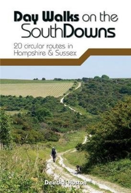
- Day Walks on the South Downs
- 20 circular routes in Hampshire & Sussex Read more
- Also available from:
- De Zwerver, Netherlands
- Stanfords, United Kingdom
De Zwerver
Netherlands
2020
Netherlands
2020
- Wandelgids Day Walks n the South Downs | Vertebrate Publishing
- 20 circular routes in Hampshire & Sussex Read more

Stanfords
United Kingdom
2020
United Kingdom
2020
- Day Walks on the South Downs: 20 circular routes in Hampshire & Sussex
- Day Walks on the South Downs features 20 circular routes, between 6 and 14 miles (9km and 22km) in length, suitable for hill walkers of all abilities.The routes are split into three geographical areas - Hampshire, West Sussex and East Sussex - and include walks to the most historic and beautiful areas of the South Downs National Park, including... Read more

- Also available from:
- De Zwerver, Netherlands
- Stanfords, United Kingdom
De Zwerver
Netherlands
Netherlands

Stanfords
United Kingdom
United Kingdom
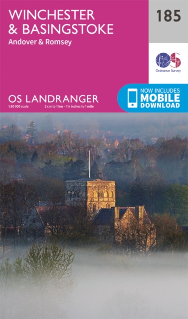
- Winchester, Basingstoke, Andover & Romsey OS Landranger Map 185 (paper)
- Winchester and Basingstoke area, including the westernmost part of the South Downs National Park and a section of the South Downs Way, on a paper version of map No. 185 from the Ordnance Survey’s Landranger series at 1:50,000, with contoured and GPS compatible topographic mapping plus tourist information.MOBILE DOWNLOADS: As well as the... Read more

The Book Depository
United Kingdom
2022
United Kingdom
2022
- South Downs Way (Trailblazer British Walking Guides) 2022
- Practical guide with 60 Large-Scale Walking Maps (1:20,000) & Guides to 49 Towns & Villages - Planning, Places To Stay, Places to Eat Read more
- Also available from:
- Stanfords, United Kingdom

Stanfords
United Kingdom
2022
United Kingdom
2022
- South Downs Way (Trailblazer British Walking Guides): Practical guide with 60 Large-Scale Walking Maps (1:20,000) & Guides to 49 Towns & Villages - Planning, Places To Stay, Places to Eat: 2022
- Practical, complete guide to walking the South Downs Way, a 100-mile National Trail footpath which follows the line of chalk hills stretching from Winchester to Eastbourne in southern England. Includes * 82 Maps: 60 large-scale walking maps - 1:20,000 (3-1/8 inches to 1 mile), 11 town plans, 10 stage maps with trail profiles showing hills and... Read more

- Also available from:
- De Zwerver, Netherlands
- Stanfords, United Kingdom

De Zwerver
Netherlands
Netherlands

Stanfords
United Kingdom
United Kingdom
- Winchester, New Alresford & East Meon OS Explorer Map OL32 (paper)
- Winchester, New Alresford and East Meon area of Hampshire on a detailed topographic and GPS compatible map OL32, paper version, from the Ordnance Survey’s 1:25,000 Explorer series. Coverage includes part of the South Downs National Park with the westernmost section of the South Downs Way National Trail. Other trails include the Monarch’s Way,... Read more

The Book Depository
United Kingdom
United Kingdom
- New Hampshire Day Hikes
- A Folding Pocket Guide to Gear, Planning & Useful Tips Read more

- Also available from:
- Stanfords, United Kingdom

Stanfords
United Kingdom
United Kingdom
- Haslemere & Petersfield - Midhurst & Selborne OS Explorer Active Map OL33 (waterproof)
- Haslemere and Petersfield area of Hampshire, Sussex and Surrey on a detailed topographic and GPS compatible map OL33, waterproof version, from the Ordnance Survey’s 1:25,000 Explorer series. Coverage extends from Alton and Witley southwards to Midhurst, and includes parts of the South Downs National Park and the Surrey Downs Area of Outstanding... Read more
Karten

The Book Depository
United Kingdom
United Kingdom
- Eastbourne and Beachy Head
- Eastbourne and Beachy Head at 1:25,000 in a series of Walker Read more
- Also available from:
- Stanfords, United Kingdom

Stanfords
United Kingdom
United Kingdom
- Eastbourne & Beachy Head AA Walker`s Map 30
- Eastbourne and Beachy Head at 1:25,000 in a series of Walker’s Maps published by the AA with the cartography from the Ordnance Survey’s Explorer series. Coverage includes Seven Sisters and the Cuckmere Haven, the start of the South Downs Way, Seaford, Newhaven, Alfriston, Firle, Glynde, Ringmer, Uckfield, Buxted, Heathfield, Herstmonceux,... Read more

De Zwerver
Netherlands
Netherlands
- Wandelkaart - Fietskaart South Downs Way | Harvey Maps
- The South Downs Way, a 160km / 100 mile National Trail from Eastbourne to Winchester, presented at 1:40,000 on a light, waterproof and tear-resistant map from Harvey Map Services. The route is shown on nine panels, with additional small street plans of Eastbourne and Winchester. Map legend and the accompanying notes are also in French and... Read more
- Also available from:
- Stanfords, United Kingdom

Stanfords
United Kingdom
United Kingdom
- South Downs Way Harvey National Trail XT40
- The South Downs Way, a 160km / 100 mile National Trail from Eastbourne to Winchester, presented at 1:40,000 on a light, waterproof and tear-resistant map from Harvey Map Services. The route is shown on nine panels, with additional small street plans of Eastbourne and Winchester. Map legend and the accompanying notes are also in French and... Read more
De Zwerver
Netherlands
2023
Netherlands
2023

Stanfords
United Kingdom
United Kingdom
- Chichester and the South Downs 1897-1900
- Map No. 197, Chichester and the South Downs 1897-1900, in the Cassini Historical Series of old Ordnance Survey mapping of England and Wales at 1:50,000 in a format designed to offer a convenient comparison with the present day coverage from the OS, and most locations in three different editions. Old historical maps have been combined so that... Read more
Stanfords
United Kingdom
United Kingdom
- Chichester and the South Downs 1810-1920 (3-map set)
- Map No. 197, Chichester and the South Downs 1810-1920 (3-map set), in the Cassini Historical Series of old Ordnance Survey mapping of England and Wales at 1:50,000 in a format designed to offer a convenient comparison with the present day coverage from the OS, and most locations in three different editions. Old historical maps have been... Read more

Stanfords
United Kingdom
United Kingdom
- New Hampshire - Vermont DeLorme Atlas & Gazetteer
- New Hampshire Recreational Atlas & Gazetteer at 1:100,000 approx. in a series of large format paperback state atlases from DeLorme, with detailed, contoured, GPS compatible topographic mapping. The atlas includes indexed street plans of 67 main cities and towns, including Concord, Plymouth, Manchester, Exeter, Rochester, Laconia, Dover, Nashua,... Read more

Stanfords
United Kingdom
United Kingdom
- Hampshire & The Isle of Wight Cycle Tours
- Hampshire and the Isle of Wight is one of 10 titles in the updated Cycle Tours series. The series has now been in continuous print for more than 15 years and with regular route revisions and updating the successful formula has gathered a large following.Each book in the series contains 20 routes all of which are either totally new or have been... Read more

Stanfords
United Kingdom
United Kingdom
- Great Cycle Routes: The North and South Downs
- Great Cycle Routes: The North and South Downs provides a selection of enjoyable on and off road rides in the area, varying length and level of difficulty, and ranging in duration from a leisurely couple of hours to full day excursions. The book features twenty five individually graded routes, each with a factfile and full information. Useful... Read more

Stanfords
United Kingdom
United Kingdom
- Surrey & West Sussex Cycle Tours
- ”Surrey and West Sussex” is one of 10 titles in the updated ”Cycle Tours” series. The series has now been in continuous print for more than 15 years and with regular route revisions and updating the successful formula has gathered a large following. Each book in the series contains 20 routes all of which are either totally new or have been... Read more

Stanfords
United Kingdom
United Kingdom
- Kent & East Sussex Cycle Tours
- ”Kent and East Sussex” is one of 10 titles in the ”Cycle Tours” series. The series has now been in continuous print for more than 15 years and with regular route revisions and updating the successful formula has gathered a large following.Each book in the series contains 20 routes all of which are either totally new or have been re-ridden and... Read more

Stanfords
United Kingdom
2017
United Kingdom
2017
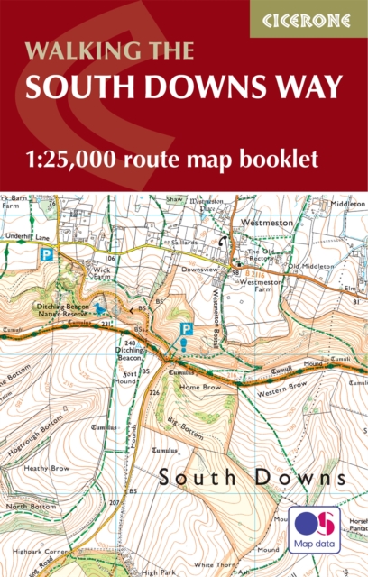
- South Downs Way A-Z Adventure Atlas
- The South Downs Way at 1:25,000 in a series of handy A5 size Adventure Atlases from Geographers` A-Z Map Company with cartography from the Ordnance Survey’s Explorer series. The atlas shows the whole course of this national trail from Winchester to Eastbourne, with the variants via the Beachy Head and the Seven Sisters, or via Jevington.To see... Read more

Stanfords
United Kingdom
United Kingdom
- England Coast Path Adventure Map - Minehead to Brean Down
- The A-Z Adventure Series of maps combines the best of OS and A-Z, creating the perfect companion for walkers, off-road cyclists, horse riders and anyone wishing to explore the great outdoors.This official Minehead to Brean Down Adventure Map covers a 58 mile (93km) section of the England Coast Path, a new National Trail around England`s coast.... Read more
Stanfords
United Kingdom
United Kingdom
- Chichester and the South Downs 1810-1813
- Map No. 197, Chichester and the South Downs 1810-1813, in the Cassini Historical Series of old Ordnance Survey mapping of England and Wales at 1:50,000 in a format designed to offer a convenient comparison with the present day coverage from the OS, and most locations in three different editions. Old historical maps have been combined so that... Read more
Stanfords
United Kingdom
United Kingdom
- Chichester and the South Downs 1919-1920
- Map No. 197, Chichester and the South Downs 1919-1920, in the Cassini Historical Series of old Ordnance Survey mapping of England and Wales at 1:50,000 in a format designed to offer a convenient comparison with the present day coverage from the OS, and most locations in three different editions. Old historical maps have been combined so that... Read more