Menorca 1 : 50 000 Autokarte ab 10.9 EURO 1:50. 000. Touristische Informationen, Entfernungen in km, Marinas Freytag & Berndt Auto + FreizeitkarteRead more
Topographic coverage of the Balearic Islands at 1:50,000 in the MTN50 (Mapa Topográfico Nacional) series from the Instituto Geográfico Nacional – Centro Nacional de Información Geografica, the country’s civilian survey organization. The maps have contours at 20m intervals, enhanced by relief shading, plus colouring and/or graphics to show...Read more
Topographic coverage of the Balearic Islands at 1:25,000 published by the Instituto Geográfico Nacional – Centro Nacional de Información Geografica, the country’s civilian survey organization. The maps have contours at 10m intervals and colouring and/or graphics to show different types of vegetation or land use. Boundaries of national parks and...Read more
Chart atlas covering the Islas Baleares - Ibiza, Formentera, Mallorca, Cabrera and Menorca. 25 sheets provide all of the necessary information for passage planning and detailed approaches to the harbours and anchorages of this appealing cruising ground. In loose-leaf A2 format in a tough plastic wallet.A voucher code to download the relevant...Read more
Topographic coverage of the Balearic Islands at 1:25,000 published by the Instituto Geográfico Nacional – Centro Nacional de Información Geografica, the country’s civilian survey organization. The maps have contours at 10m intervals and colouring and/or graphics to show different types of vegetation or land use. Boundaries of national parks and...Read more
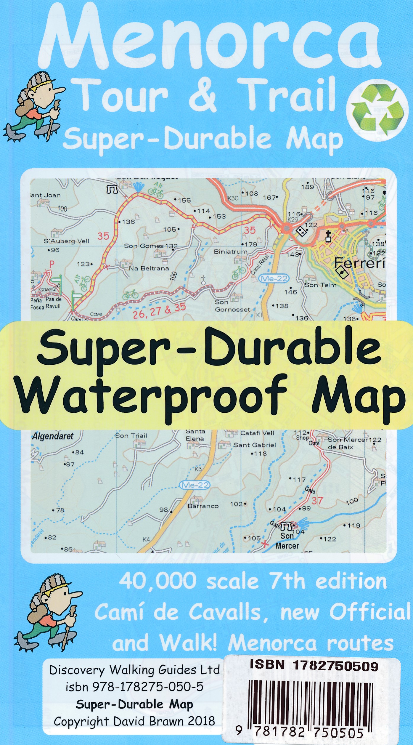
Menorca at 1:50,000 on a contoured, GPS compatible map from Editorial Alpina with a special overprint for the GR223 – Camí de Cavalls, a long-distance hiking path along the island’s coast, plus local trails, mountain bike routes, accommodation, sights, etc, plus a booklet in Catalan only.The map has contours at 20m intervals, with additional...Read more
Topographic coverage of the Balearic Islands at 1:25,000 published by the Instituto Geográfico Nacional – Centro Nacional de Información Geografica, the country’s civilian survey organization. The maps have contours at 10m intervals and colouring and/or graphics to show different types of vegetation or land use. Boundaries of national parks and...Read more
Topographic coverage of the Balearic Islands at 1:25,000 published by the Instituto Geográfico Nacional – Centro Nacional de Información Geografica, the country’s civilian survey organization. The maps have contours at 10m intervals and colouring and/or graphics to show different types of vegetation or land use. Boundaries of national parks and...Read more
Topographic coverage of the Balearic Islands at 1:25,000 published by the Instituto Geográfico Nacional – Centro Nacional de Información Geografica, the country’s civilian survey organization. The maps have contours at 10m intervals and colouring and/or graphics to show different types of vegetation or land use. Boundaries of national parks and...Read more
Eschenbach i.d.OPf. in a series of GPS compatible recreational editions of the Bavarian topographic survey at 1:25,000, with waymarked hiking trails and cycling routes, campsites and youth hostels, etc. Coverage includes Creußen, Kirchenthumbach, Speichersdorf, Kemnath, Neustadt am Kulm, Grafenwöhr.Contours used in this map vary between 5 to...Read more
Topographic coverage of the Balearic Islands at 1:50,000 in the MTN50 (Mapa Topográfico Nacional) series from the Instituto Geográfico Nacional – Centro Nacional de Información Geografica, the country’s civilian survey organization. The maps have contours at 20m intervals, enhanced by relief shading, plus colouring and/or graphics to show...Read more
Topographic coverage of the Balearic Islands at 1:50,000 in the MTN50 (Mapa Topográfico Nacional) series from the Instituto Geográfico Nacional – Centro Nacional de Información Geografica, the country’s civilian survey organization. The maps have contours at 20m intervals, enhanced by relief shading, plus colouring and/or graphics to show...Read more
Topographic coverage of the Balearic Islands at 1:25,000 published by the Instituto Geográfico Nacional – Centro Nacional de Información Geografica, the country’s civilian survey organization. The maps have contours at 10m intervals and colouring and/or graphics to show different types of vegetation or land use. Boundaries of national parks and...Read more