Alpen Weitwanderweg
Beschreibung
- Name Alpen Weitwanderweg
- Länge von Wanderweg 160 km, 99 Meilen
- Länge in Tagen 7 Tage
- Anfang von Wanderweg Pass Hallturm
- Ende von Wanderweg Bischofswiesen
- Traildino Schwierigkeit SW, Anspruchsvolle Wanderung, Bergwanderung
- Schwierigkeitsgrad Berg- und Alpinwanderung T2, Bergwandern
Pass Hallturm – Bischofswiesen, 160 km, 7 days
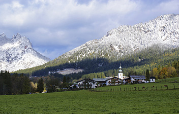
This trail runs in both Germany - Berchtesgadener Alps - and Austria - Salzburgerland. It is the accomplishment of coöperation between both regions, especially groups of sport hikers from both countries. In seven days, you will climb 5.200 m. The reward of the trail is more than sport: the trail is also aimed at those with an interest in history, and the lover of nature and scenery.
However, the Alpenweitwanderweg does stay on the relatively easy northern side of the mountains, so you will miss the more dramatic and inaccessible southern part of these limestone mountains.
Links
Fakten
Berichte
Führer und Karten
Übernachtung
Organisationen
Reisebüros
GPS
Sonstiges
Karten

Stanfords
United Kingdom
United Kingdom
- Zell am See - Kaprun - Saalbach F&B WK382
- Zell-am-See - Kaprun - Saalbach area of the Austrian Alps presented at 1:50,000 in a series of contoured and GPS compatible outdoor leisure map from Freytag & Berndt with hiking and cycling routes, mountain huts, campsites and youth hostels, local bus stops, plus other tourist information. To see the list of currently available titles in this... Read more

Stanfords
United Kingdom
United Kingdom
- Hohe Wand - Schneebergland - Gutenstein Alps - Piestingtal - Lilienfeld F&B WK012
- Hohe Wand - Piestingtal - Triestingtal - Gölsental - Gutensteier Alpen – Lilienfeld area south-west of Vienna presented at 1:50,000 in a series of contoured and GPS compatible outdoor leisure map from Freytag & Berndt with hiking and cycling routes, mountain huts, campsites and youth hostels, local bus stops, plus other tourist information.To... Read more


