
Val Grande
Beschreibung
Karte

Wanderwege Region
Links
Fakten
Berichte
Führer und Karten
Übernachtung
Organisationen
Reisebüros
GPS
Sonstiges
Bücher
De Zwerver
Netherlands
2022
Netherlands
2022
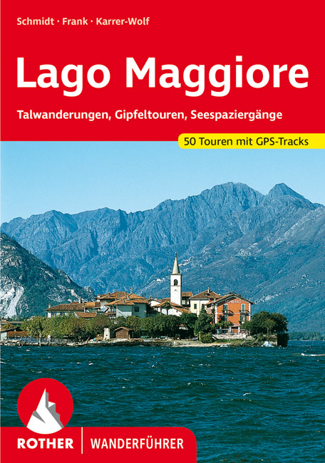
- Wandelgids 61 Lago Maggiore | Rother Bergverlag
- Uitstekende wandelgids met een groot aantal dagtochten in dal en hooggebergte. Met praktische informatie en beperkt kaartmateriaal! Wandelingen in verschillende zwaarte weergegeven in rood/blauw/zwart. Touristen, die den Lago Maggiore in jedem Jahr zu Hunderttausenden besuchen, erleben die Berge, in die der See eingebettet ist, oft nur als... Read more
- Also available from:
- Bol.com, Netherlands
- Bol.com, Belgium
Bol.com
Netherlands
2015
Netherlands
2015
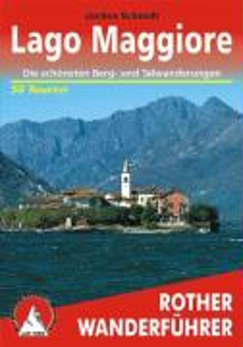
- Lago Maggiore
- 50 ausgew hlte Wanderungen im Varesotto, Alto Luinese, Alto und Basso Verbano sowie im Nationalpark Val Grande. Read more
Bol.com
Belgium
2015
Belgium
2015
- Lago Maggiore
- 50 ausgew hlte Wanderungen im Varesotto, Alto Luinese, Alto und Basso Verbano sowie im Nationalpark Val Grande. Read more
Bol.com
Netherlands
2016
Netherlands
2016
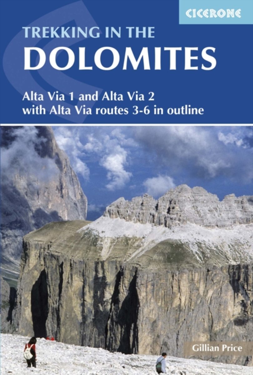
- Trekking in the Dolomites
- Italy's famous Alta Via long-distance walking routes are spread across the Dolomites running roughly north to south and across to the Austrian border. Increasing in difficulty from AV1 to AV6, they vary in length from 6 to 13 days and range from easy ambles to difficult aided climbs. For the two first routes, described in detail in this guide,... Read more
- Also available from:
- Bol.com, Belgium
Bol.com
Belgium
2016
Belgium
2016
- Trekking in the Dolomites
- Italy's famous Alta Via long-distance walking routes are spread across the Dolomites running roughly north to south and across to the Austrian border. Increasing in difficulty from AV1 to AV6, they vary in length from 6 to 13 days and range from easy ambles to difficult aided climbs. For the two first routes, described in detail in this guide,... Read more
Karten

The Book Depository
United Kingdom
2020
United Kingdom
2020
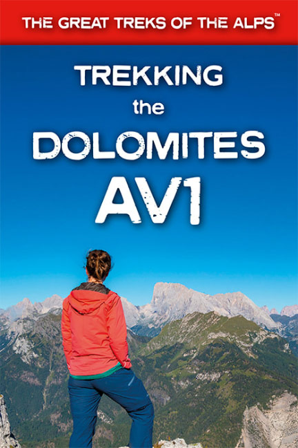
- Trekking the Dolomites AV1
- This is only guidebook exclusively for the AV1 and contains everything needed plan and walk Italy`s most popular long-distance route. The guidebook contains real maps - Tabacco 1:25,000 - the finest maps available for the Dolomites, thus making navigation easy with no need to carry additional maps.The AV1 is the premier route in the... Read more
- Also available from:
- De Zwerver, Netherlands
- Stanfords, United Kingdom
De Zwerver
Netherlands
2020
Netherlands
2020
- Wandelgids Trekking the Dolomites Av1 | Knife Edge Outdoor
- This is only guidebook exclusively for the AV1 and contains everything needed plan and walk Italy`s most popular long-distance route. The guidebook contains real maps - Tabacco 1:25,000 - the finest maps available for the Dolomites, thus making navigation easy with no need to carry additional maps.The AV1 is the premier route in the... Read more

Stanfords
United Kingdom
2020
United Kingdom
2020
- Trekking the Dolomites AV1
- This is only guidebook exclusively for the AV1 and contains everything needed plan and walk Italy`s most popular long-distance route. The guidebook contains real maps - Tabacco 1:25,000 - the finest maps available for the Dolomites, thus making navigation easy with no need to carry additional maps.The AV1 is the premier route in the... Read more
De Zwerver
Netherlands
Netherlands
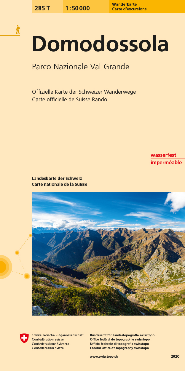
- Wandelkaart 285T Domodossola | Swisstopo
- Domodossola - Val Grande National Park, map No. 285T, at 1:50,000 in a special hiking edition of the country Read more
- Also available from:
- Stanfords, United Kingdom

Stanfords
United Kingdom
United Kingdom
- Domodossola - Val Grande National Park Swisstopo Hiking 285T
- Domodossola - Val Grande National Park, map No. 285T, at 1:50,000 in a special hiking edition of the country’s topographic survey, published by Swisstopo in cooperation with the Swiss Hiking Federation. The map covers the Italian side of the border, extending from Domodossola itself to Verbania on Lake Maggiore, and has the same overprint as on... Read more

De Zwerver
Netherlands
Netherlands
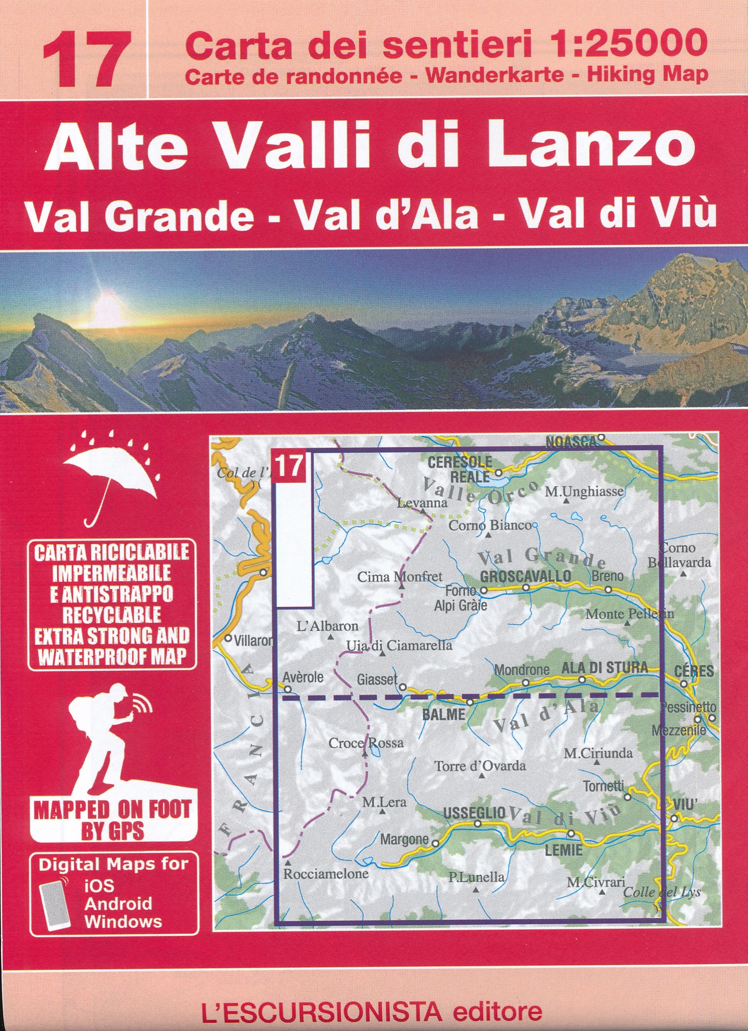
- Wandelkaart 02 Valli di lanzo e Moncenisio | IGC - Istituto Geografico Centrale
- Lanzo and Moncenisio Valleys, map no. 2, in a series contoured hiking maps at 1:50,000 with local trails, long-distance footpaths, mountain accommodation, etc. from the Turin based Istituto Geografico Centrale covering the Italian Alps and Piedmont, the lakes and northern Lombardy, and the Italian Riviera.The maps have contours at 50m... Read more
- Also available from:
- Stanfords, United Kingdom

Stanfords
United Kingdom
United Kingdom
- Lanzo and Moncenisio Valleys IGC 2
- Lanzo and Moncenisio Valleys in a series contoured hiking maps at 1:50,000 with local trails, long-distance footpaths, mountain accommodation, etc. from the Turin based Istituto Geografico Centrale. This title also includes an overprint showing cycle routes.Maps in this series have contours at 50m intervals, enhanced by shading and graphic... Read more

Stanfords
United Kingdom
United Kingdom
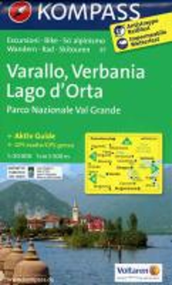
- Varallo - Verbania - Lake Orta - NP Val Grande Kompass 97
- Varallo - Verbania - Lake Orta, including the western shores of Lake Maggiore and Val Grande National Park, on a GPS compatible hiking and recreational map at 1:50,000 from Kompass, printed on durable, waterproof and tear-resistant synthetic paper.KOMPASS HIKING MAPS OF ITALY:This title is part of an extensive series of walking maps from... Read more

Stanfords
United Kingdom
United Kingdom
- Lake Maggiore - Lake Varese Kompass 90
- recreational map at 1:50,000 from Kompass. Coverage extends from Locarno to Arona on the southern tip of Lake Maggiore, and from Lago di Mergozzo in the west to Lugano in the east, and includes part of Parco Nazionale delle Val Grande. Accompanying booklet has 33 pages in English, providing descriptions of best sights, suggestions for three... Read more
Bol.com
Netherlands
Netherlands
- Kompass WK97 Varallo, Verbania, Lago d'Orta
- Deze Kompass wandelkaart, schaal 1:50 000, is ideaal om uw route uit te stippelen en om onderweg te gebruiken • naast de bekende bestemmingen, worden ook de minder bekende vermeld • openbaar vervoer bij begin- of eindpunt van een route aangegeven • eenvoudige wandelingen tot pittige (berg)tochten, voor getrainde en ongetrainde wandelaars • met... Read more
- Also available from:
- Bol.com, Belgium
Bol.com
Belgium
Belgium
- Kompass WK97 Varallo, Verbania, Lago d'Orta
- Deze Kompass wandelkaart, schaal 1:50 000, is ideaal om uw route uit te stippelen en om onderweg te gebruiken • naast de bekende bestemmingen, worden ook de minder bekende vermeld • openbaar vervoer bij begin- of eindpunt van een route aangegeven • eenvoudige wandelingen tot pittige (berg)tochten, voor getrainde en ongetrainde wandelaars • met... Read more