The Book Depository
United Kingdom
The Book Depository
United Kingdom
2017
» Click to open
De Zwerver
Netherlands
2017
  • Wandelgids Yorkshire Dales | Pocket Mountains
  • The Yorkshire Dales combine a wild limestone landscape of high rolling moorland gouged by dramatic caves and cascading waterfalls with peaceful farmland carpeted in wildflowers and dotted with ruined abbeys, ancient stone walls and barns, and timeless villages waiting to be discovered.The 40 moderate walks in this collection from award winning... Read more
Stanfords
United Kingdom
2017
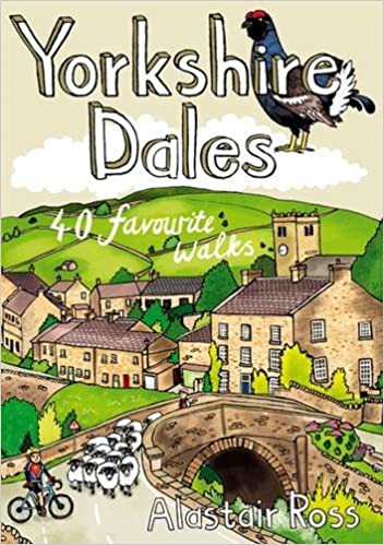
  • Yorkshire Dales: 40 Favourite Walks
  • The Yorkshire Dales combine a wild limestone landscape of high rolling moorland gouged by dramatic caves and cascading waterfalls with peaceful farmland carpeted in wildflowers and dotted with ruined abbeys, ancient stone walls and barns, and timeless villages waiting to be discovered.The 40 moderate walks in this collection from award winning... Read more
» Click to close
The Book Depository
United Kingdom
» Click to open
Stanfords
United Kingdom
» Click to close
The Book Depository
United Kingdom
2018
» Click to open
» Click to close
The Book Depository
United Kingdom
2017
» Click to open
Stanfords
United Kingdom
2017
  • The Lune Valley and Howgills: 40 Scenic Fell, River and Woodland Walks
  • This guidebook offers a wide range of walks from the source of the river Lune in the Howgill Fells to Glasson Dock, just below Lancaster. The 40 day walks range between 3 and 11 miles in length and are all illustrated with extracts of 1:50,000 OS mapping. They explore the infinitely varied landscape as the river Lune flows between the Lake... Read more
» Click to close
The Book Depository
United Kingdom
» Click to open
Stanfords
United Kingdom
  • Ipswich, The Naze & Clacton-on-Sea OS Landranger Map 169 (paper)
  • Ipswich with Harwich and The Naze area, including part of the E2 European Long-distance Path, on a paper version of map No. 169 from the Ordnance Survey’s Landranger series at 1:50,000, with contoured and GPS compatible topographic mapping plus tourist information.MOBILE DOWNLOADS: As well as the physical edition of the map, each Landranger... Read more
» Click to close
The Book Depository
United Kingdom
» Click to open
Stanfords
United Kingdom
» Click to close
The Book Depository
United Kingdom
» Click to open
Stanfords
United Kingdom
  • Stratford-upon-Avon, Warwick & Banbury OS Landranger Map 151 (paper)
  • The area between Stratford-upon-Avon, Warwick and Banbury, including the northern part of the Cotswold Hills and part of the Cotswold Way / E2 European Long-distance Path, on a paper version of map No. 151 from the Ordnance Survey’s Landranger series at 1:50,000, with contoured and GPS compatible topographic mapping plus tourist... Read more
» Click to close
The Book Depository
United Kingdom
» Click to open
Stanfords
United Kingdom
  • Cheviot Hills - Jedburgh & Wooler OS Explorer Active Map OL16 (waterproof)
  • The Cheviot Hills on a detailed topographic and GPS compatible map OL16, waterproof version, from the Ordnance Survey’s 1:25,000 Explorer series. Coverage includes Jedburgh, Woolmer, part of the Northumberland National Park, the peaks of The Cheviot, Corby Pike, Cold Law, Scrathy Holes and Windy Gyle, Catcleugh Reservoir, sections of the... Read more
» Click to close
The Book Depository
United Kingdom
» Click to open
Stanfords
United Kingdom
  • Cheltenham, Cirencester & Stow-on-the-Wold OS Landranger Map 163 (paper)
  • Cheltenham and Cirencester area, including sections of the Thames Path, the Cotswold Way and the E2 European Long-distance Path, on a paper version of map No. 163 from the Ordnance Survey’s Landranger series at 1:50,000, with contoured and GPS compatible topographic mapping plus tourist information.MOBILE DOWNLOADS: As well as the physical... Read more
» Click to close
The Book Depository
United Kingdom
» Click to open
Stanfords
United Kingdom
  • Ribble Valley and Bowland: Short Scenic Walks
  • This brand-new title is one of three concurrent additions to the updated series of Paul Hannon`s `Short Scenic Walks` guidebooks. The principal feature is that all walks are less than five miles in length, offering a perfect half day`s stroll for families, casual walkers and all who want to enjoy a leisurely exploration of Britain`s outstanding... Read more
» Click to close
The Book Depository
United Kingdom
» Click to open
Stanfords
United Kingdom
  • Oxford, Chipping Norton & Bicester OS Landranger Map 164 (paper)
  • Oxford area, including sections of the Thames Path and the E2 European Long-distance Path, on a paper version of map No. 164 from the Ordnance Survey’s Landranger series at 1:50,000, with contoured and GPS compatible topographic mapping plus tourist information.MOBILE DOWNLOADS: As well as the physical edition of the map, each Landranger title... Read more
» Click to close
The Book Depository
United Kingdom
» Click to open
» Click to close
The Book Depository
United Kingdom
» Click to open
Stanfords
United Kingdom
» Click to close
The Book Depository
United Kingdom
2014
» Click to open
De Zwerver
Netherlands
2008
  • Wandelgids Walking in the Forest of Bowland and Pendle | Cicerone
  • This handy guidebook contains 40 diverse circular day walks suitable for walkers with navigational skills. There is a variety of terrain covered in the Forest of Bowland and Pendle which makes it perfect for those who wish to explore an AONB. Some of the routes covered include: Ward's Stone, Pendle Hill, Longridge Fell and Fair Snape Fell. Read more
Stanfords
United Kingdom
2014
  • Forest of Bowland and Pendle Walking
  • Experienced walker Terry Marsh’s Cicerone guide to Walking in the Forest of Bowland and Pendle explores some of the walking possibilities in two of Lancashire’s Areas of Outstanding Beauty. The Forest of Bowland stretches over an area of 310 square miles and combined with the beautiful countryside of Pendle provide fertile and varied walking... Read more
» Click to close