
Brecon Beacons
Beschreibung
Mountain range in the south of Wales. Also, the name is used to refer to the Brecon Beacons National Park, which comprises a larger area and other hill ranges as well. Popular for hiking. Pen y Fan, south Wales highest mountain, is one of the popular destinations.
Wanderwege Region
Links
Fakten
Berichte
Führer und Karten
Übernachtung
Organisationen
Reisebüros
GPS
Sonstiges
Bücher


The Book Depository
United Kingdom
United Kingdom
- Walks to South Wales' Lakes and Waterfalls
- Black Mountain, Brecon Beacons, the Black Mountains & the Vale of Neath Read more

The Book Depository
United Kingdom
United Kingdom
- Also available from:
- Stanfords, United Kingdom

Stanfords
United Kingdom
United Kingdom
- Brecon Beacons Western & Central OS Explorer Active Map OL12 (waterproof)
- The Western and central areas of the Brecon Beacons National Park on a detailed topographic and GPS compatible map OL12, waterproof version, from the Ordnance Survey’s 1:25,000 Explorer series. Coverage extends from Merthyr Tydfil in the south-east to Llandovery in the north-west and highlights include the Black Mountain, Fforest Fawr, the... Read more

The Book Depository
United Kingdom
2019
United Kingdom
2019
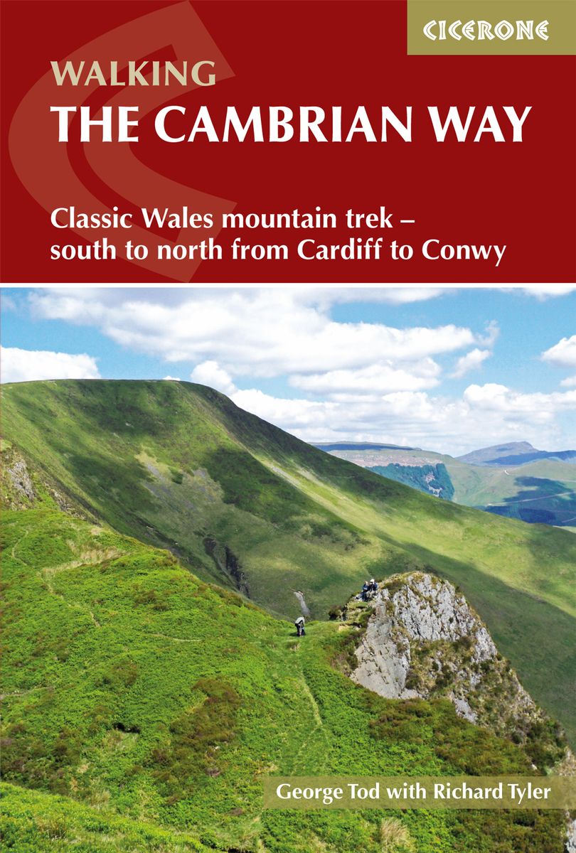
- The Cambrian Way
- Classic Wales mountain trek - south to north from Cardiff to Conwy Read more
- Also available from:
- De Zwerver, Netherlands
- Stanfords, United Kingdom
De Zwerver
Netherlands
2019
Netherlands
2019
- Wandelgids The Cambrian Way | Cicerone
- Guidebook to the Cambrian Way, a challenging three-week mountain trek through Wales from Cardiff to Conwy. The 470km unwaymarked route is presented from south to north. Often sticking to long, beautiful ridgelines, it crosses wild and rugged terrain and visits many of Wales's highest mountains, including Snowdon. Read more

Stanfords
United Kingdom
2019
United Kingdom
2019
- The Cambrian Way: Classic Wales mountain trek - south to north from Cardiff to Conwy
- Dubbed `the mountain connoisseurs` walk`, the Cambrian Way stretches 479km between the mighty castles of Cardiff in the south and Conwy on the north coast. Traversing the heartland of Wales, the challenging route crosses the Brecon Beacons, the Cambrian Mountains and Snowdonia, passing through two national parks and visiting many of the... Read more

The Book Depository
United Kingdom
2014
United Kingdom
2014
- The Mountains of England and Wales: Vol 1 Wales
- The Nuttalls are hills over 2000ft high in England and Wales. The 190 Nuttalls in Wales are split into: Carneddau, Glyders, Snowdon, Moel Hebog, Moelwyns, Arenigs, Berwyns, Arans, Rhinogs, Cadair Idris, central Wales, Black Mountains, Brecon Beacons. Definitive lists, detailed route descriptions, maps and drawings of Wales' highest peaks. Read more
- Also available from:
- Stanfords, United Kingdom

Stanfords
United Kingdom
2014
United Kingdom
2014
- The Mountains of England and Wales: Vol. 1 - Wales
- The Mountains of England and Wales - Volume 1 is John and Anne Nuttall’s Cicerone guide to walking the highest summits in the country. The guide describes the ascent of all 190 mountains in Wales and is a companion to the authors’ similar work on England. Each of the mountains are grouped by range, allowing walkers to easily find relevant and... Read more

- Also available from:
- Stanfords, United Kingdom

Stanfords
United Kingdom
United Kingdom
- The Black Mountains - Abergavenny OS Landranger Active Map 161 (waterproof)
- The Black Mountains in the Brecon Beacons National Park, including a part of the Offa’s Dyke Path, on a waterproof and tear-resistant OS Active version of map No. 161 from the Ordnance Survey’s Landranger series at 1:50,000, with contoured and GPS compatible topographic mapping plus tourist information.MOBILE DOWNLOADS: As well as the physical... Read more

The Book Depository
United Kingdom
United Kingdom
- A Boot Up the Brecon Beacons
- 10 Leisure Walks of Discovery Read more


- Also available from:
- De Zwerver, Netherlands
- Stanfords, United Kingdom
De Zwerver
Netherlands
Netherlands

Stanfords
United Kingdom
United Kingdom
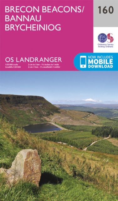
- Brecon Beacons OS Landranger Map 160 (paper)
- The central and western part of the Brecon Beacons National Park on a paper version of map No. 160 from the Ordnance Survey’s Landranger series at 1:50,000, with contoured and GPS compatible topographic mapping plus tourist information.MOBILE DOWNLOADS: As well as the physical edition of the map, each Landranger title now includes a code for... Read more

The Book Depository
United Kingdom
2016
United Kingdom
2016
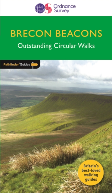
- Brecon Beacons
- Pathfinder Brecon Beacons covering the Maen Madoc, Carn Goch and Carreg Cennen. This selection offers interest, regional variety and balance of routes in the Brecon Beacons providing the best walks in the area. From an easy stroll through Llangors Lake to the much more challenging walks in Waun Fach this volume contains something for everyone.... Read more
- Also available from:
- De Zwerver, Netherlands
- Stanfords, United Kingdom
De Zwerver
Netherlands
2016
Netherlands
2016
- Wandelgids 18 Pathfinder Guides Brecon Beacons | Ordnance Survey
- Pathfinder Brecon Beacons covering the Maen Madoc, Carn Goch and Carreg Cennen. This selection offers interest, regional variety and balance of routes in the Brecon Beacons providing the best walks in the area. From an easy stroll through Llangors Lake to the much more challenging walks in Waun Fach this volume contains something for everyone.... Read more

Stanfords
United Kingdom
2016
United Kingdom
2016
- Brecon Beacons & Glamorgan Walks
- Pathfinder Brecon Beacons covering the Maen Madoc, Carn Goch and Carreg Cennen. This selection offers interest, regional variety and balance of routes in the Brecon Beacons providing the best walks in the area. From an easy stroll through Llangors Lake to the much more challenging walks in Waun Fach this volume contains something for everyone.... Read more

The Book Depository
United Kingdom
United Kingdom
- All Terrain Pushchair Walks Brecon Beacons
- A comprehensive and practical guide for families with all terrain pushchairs, wishing to enjoy the beauty of the Brecon Beacons. There are 30 graded routes tested and cosen for their five children. Incluses a range of high and low level walks, with lakes and mountains. Read more


The Book Depository
United Kingdom
2022
United Kingdom
2022
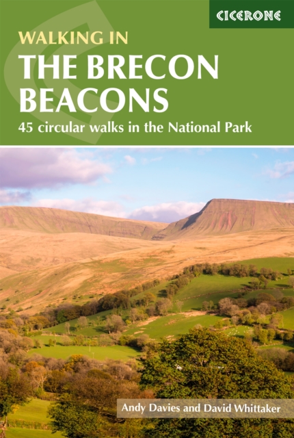
- Walking in the Brecon Beacons
- 45 circular walks in the National Park Read more
- Also available from:
- De Zwerver, Netherlands
- Stanfords, United Kingdom
De Zwerver
Netherlands
2022
Netherlands
2022
- Wandelgids Walking on the Brecon Beacons | Cicerone
- Guidebook to 45 graded circular walks in the Brecon Beacons National Park, perfect for those wishing to discover the diversity of the region, away from the crowds. The routes range from 4 to 24km and cover the north-eastern, eastern and south-western valleys and ridges, Fforest Fawr, Waterfall Country, the Black Mountain (Mynydd Du) and the... Read more

Stanfords
United Kingdom
2022
United Kingdom
2022
- Walking in the Brecon Beacons: 45 circular walks in the National Park
- Guidebook to 45 graded circular walks in the Brecon Beacons National Park, perfect for those wishing to discover the diversity of the region, away from the crowds. The routes range from 4 to 24km and cover the north-eastern, eastern and south-western valleys and ridges, Fforest Fawr, Waterfall Country, the Black Mountain (Mynydd Du) and the... Read more

The Book Depository
United Kingdom
2022
United Kingdom
2022
- Top 10 Walks in The Brecon Beacons
- This attractive guide gives walkers ten of the finest circular, themed walks in the Brecon Beacons National Park in a popular pocketable format. With clear information, an overview and introduction for each walk, expertly written numbered directions, large scale Ordnance Survey maps, superb eye-grabbing panoramic photographs, and interpretation... Read more
- Also available from:
- De Zwerver, Netherlands
- Stanfords, United Kingdom
De Zwerver
Netherlands
2022
Netherlands
2022
- Wandelgids Brecon Beacons | Northern Eye Books
- This attractive guide gives walkers ten of the finest circular, themed walks in the Brecon Beacons National Park in a popular pocketable format. With clear information, an overview and introduction for each walk, expertly written numbered directions, large scale Ordnance Survey maps, superb eye-grabbing panoramic photographs, and interpretation... Read more

Stanfords
United Kingdom
2022
United Kingdom
2022
- Top 10 Walks in The Brecon Beacons
- This attractive guide gives walkers ten of the finest circular, themed walks in the Brecon Beacons National Park in a popular pocketable format. With clear information, an overview and introduction for each walk, expertly written numbered directions, large scale Ordnance Survey maps, superb eye-grabbing panoramic photographs, and interpretation... Read more
Karten

- Also available from:
- De Zwerver, Netherlands


The Book Depository
United Kingdom
2011
United Kingdom
2011
- Brecon Beacons
- Waterproof mountain map of Brecon Beacons from Harvey at 1:40,000, with a geological map of the region on the reverse and advice on navigating the region safely.MAIN MAP: Topography is shown through clear altitude shading, spot heights, contours at 15m intervals, and index contours at 75m intervals. A variety of symbols are used to show terrain... Read more
- Also available from:
- De Zwerver, Netherlands
- Stanfords, United Kingdom
De Zwerver
Netherlands
2011
Netherlands
2011
- Wandelkaart Brecon Beacons | Harvey Maps
- Waterproof mountain map of Brecon Beacons from Harvey at 1:40,000, with a geological map of the region on the reverse and advice on navigating the region safely.MAIN MAP: Topography is shown through clear altitude shading, spot heights, contours at 15m intervals, and index contours at 75m intervals. A variety of symbols are used to show terrain... Read more

Stanfords
United Kingdom
2011
United Kingdom
2011
- Brecon Beacons Harvey British Mountain Map XT40
- Waterproof mountain map of Brecon Beacons from Harvey at 1:40,000, with a geological map of the region on the reverse and advice on navigating the region safely.*MAIN MAP:* Topography is shown through clear altitude shading, spot heights, contours at 15m intervals, and index contours at 75m intervals. A variety of symbols are used to show... Read more

The Book Depository
United Kingdom
United Kingdom
- West and Central Brecon Beacons
- West and Central Brecon Beacons at 1:25,000 in a series of Walker Read more
- Also available from:
- Stanfords, United Kingdom

Stanfords
United Kingdom
United Kingdom
- West & Central Brecon Beacons AA Walker`s Map 18
- West and Central Brecon Beacons at 1:25,000 in a series of Walker’s Maps published by the AA with the cartography from the Ordnance Survey’s Explorer series. The map is double-sided and coverage includes Brecon beacons National Park, Merthyr Tydfil, Brecon, Trecastle, Llandovery, Llanwrda, Llandeilo, etc.Maps in the AA Walker’s series are... Read more
De Zwerver
Netherlands
2022
Netherlands
2022

Stanfords
United Kingdom
United Kingdom
- Brecon Beacons East A-Z Adventure Atlas
- The eastern part of the Brecon Beacons at 1:25,000 in a series of handy A5 size Adventure Atlases from Geographers` A-Z Map Company with cartography from the Ordnance Survey’s Explorer series. Coverage includes Brecon, Hay-on-Wye, Pandy, Abergavenny, Pontypool, Merther Tydfil, Llangynidr, Llanfrynach, Llangorse and Talgarth.To see other titles... Read more

Stanfords
United Kingdom
United Kingdom
- Swansea and Gower / Abertawe a Gwyr 1901
- Map No. 159, Swansea and Gower / Abertawe a Gwyr 1901, in the Cassini Historical Series of old Ordnance Survey mapping of England and Wales at 1:50,000 in a format designed to offer a convenient comparison with the present day coverage from the OS, and most locations in three different editions. Old historical maps have been combined so that... Read more
Stanfords
United Kingdom
United Kingdom
- The Black Mountains / Y Mynyddoedd Duon 1830-1833
- Map No. 161, The Black Mountains / Y Mynyddoedd Duon 1830-1833, in the Cassini Historical Series of old Ordnance Survey mapping of England and Wales at 1:50,000 in a format designed to offer a convenient comparison with the present day coverage from the OS, and most locations in three different editions. Old historical maps have been combined... Read more

Stanfords
United Kingdom
United Kingdom
- Cycling Lon Las Cymru: 250 miles through the heart of Wales on traffic-free paths and quiet roads
- Guidebook to cycling Lon Las Cymru, a 255 mile (410km) route from Cardiff, or 242 mile (390km) from Chepstow to Holyhead, showcasing Wales`s beautiful rural heartland. Passing through the Brecon Beacons National Park, Snowdonia National Park, and over the Black Mountains, the Brecon Beacons and the Cambrian Mountains, the route is as scenic as... Read more
Stanfords
United Kingdom
United Kingdom
- Lampeter and Llandovery / Llanbedr Pont Steffan a Llanymddyfri 1831-1834
- Map No. 146, Lampeter and Llandovery / Llanbedr Pont Steffan a Llanymddyfri 1831-1834, in the Cassini Historical Series of old Ordnance Survey mapping of England and Wales at 1:50,000 in a format designed to offer a convenient comparison with the present day coverage from the OS, and most locations in three different editions. Old historical... Read more
Stanfords
United Kingdom
United Kingdom
- Brecon Beacons / Bannau Brycheiniog 1901-1902
- Map No. 160, Brecon Beacons / Bannau Brycheiniog 1901-1902, in the Cassini Historical Series of old Ordnance Survey mapping of England and Wales at 1:50,000 in a format designed to offer a convenient comparison with the present day coverage from the OS, and most locations in three different editions. Old historical maps have been combined so... Read more
Stanfords
United Kingdom
United Kingdom
- Presteigne and Hay-on-Wye / Llanandras a’r Gelli Gandryll 1919-1920
- Map No. 148, Presteigne and Hay-on-Wye / Llanandras a’r Gelli Gandryll 1819-1920, in the Cassini Historical Series of old Ordnance Survey mapping of England and Wales at 1:50,000 in a format designed to offer a convenient comparison with the present day coverage from the OS, and most locations in three different editions. Old historical maps... Read more
Stanfords
United Kingdom
United Kingdom
- Swansea and Gower / Abertawe a Gwyr 1830-1831
- Map No. 159, Swansea and Gower / Abertawe a Gwyr 1830-1831, in the Cassini Historical Series of old Ordnance Survey mapping of England and Wales at 1:50,000 in a format designed to offer a convenient comparison with the present day coverage from the OS, and most locations in three different editions. Old historical maps have been combined so... Read more
Stanfords
United Kingdom
United Kingdom
- Lampeter and Llandovery / Llanbedr Pont Steffan a Llanymddyfri 1831-1923 (3-map set)
- Map No. 146, Lampeter and Llandovery / Llanbedr Pont Steffan a Llanymddyfri 1831-1923 (3-map set), in the Cassini Historical Series of old Ordnance Survey mapping of England and Wales at 1:50,000 in a format designed to offer a convenient comparison with the present day coverage from the OS, and most locations in three different editions. Old... Read more
Stanfords
United Kingdom
United Kingdom
- The Black Mountains / Y Mynyddoedd Duon 1919-1920
- Map No. 161, The Black Mountains / Y Mynyddoedd Duon 1919-1920, in the Cassini Historical Series of old Ordnance Survey mapping of England and Wales at 1:50,000 in a format designed to offer a convenient comparison with the present day coverage from the OS, and most locations in three different editions. Old historical maps have been combined... Read more