
New Jersey
Beschreibung
New Jersey borders on the Atlantic. This state is very populated. Hiking is best in the mountainous northern part, with several state parks and forests. Here are 72 miles of the Appalachian Trail.
The Highlands Trail is supposed to connect New Jersey to New York, Pennsylvania and Connecticut, 150 miles.
Another important trail is the Long Path, 326 miles, also in the state of New York.
The Great Eastern Trail, East Coast Greenway and Eastern Continental Trail run through New Jersey.
Karte

Wanderwege Landesteil
Links
Fakten
Berichte
Führer und Karten
Übernachtung
Organisationen
Reisebüros
GPS
Sonstiges
Bücher

The Book Depository
United Kingdom
2022
United Kingdom
2022
- Lonely Planet Epic Hikes of Australia & New Zealand
- Lace up your hiking boots for the next in Lonely Planet`s highly successful Epic Hikes series, this time exploring 50 of Australia and New Zealand`s most rewarding treks and trails. From the Routeburn Track in New Zealand`s South Island to the Cape to Cape walk in Western Australia`s Leeuwin-Naturaliste National Park, we cover a huge variety of... Read more
- Also available from:
- De Zwerver, Netherlands
- Stanfords, United Kingdom
De Zwerver
Netherlands
2022
Netherlands
2022
- Wandelgids Hikes of Australia and New Zealand | Lonely Planet
- Lace up your hiking boots for the next in Lonely Planet`s highly successful Epic Hikes series, this time exploring 50 of Australia and New Zealand`s most rewarding treks and trails. From the Routeburn Track in New Zealand`s South Island to the Cape to Cape walk in Western Australia`s Leeuwin-Naturaliste National Park, we cover a huge variety of... Read more

Stanfords
United Kingdom
2022
United Kingdom
2022
- Epic Hikes of Australia & New Zealand
- Lace up your hiking boots for the next in Lonely Planet`s highly successful Epic Hikes series, this time exploring 50 of Australia and New Zealand`s most rewarding treks and trails. From the Routeburn Track in New Zealand`s South Island to the Cape to Cape walk in Western Australia`s Leeuwin-Naturaliste National Park, we cover a huge variety of... Read more

The Book Depository
United Kingdom
United Kingdom
- Adventurous Soul: Volume 8
- Empowering Words of Wisdom & Stories from Women Who Get Outside Read more


The Book Depository
United Kingdom
United Kingdom
- A Walk for Sunshine
- A 2,160-mile Expedition for Charity on the Appalachian Trail Read more

The Book Depository
United Kingdom
2021
United Kingdom
2021
- Walking the Dales Way
- Ilkley to Bowness-on-Windermere through the Yorkshire Dales Read more
- Also available from:
- De Zwerver, Netherlands
- Stanfords, United Kingdom
De Zwerver
Netherlands
2021
Netherlands
2021
- Wandelgids The Dales Way | Cicerone
- A fully waymarked trail from Ilkley to Bowness-on-Windermere, the Dales Way links two of England`s most celebrated national parks, the Yorkshire Dales and the Lake District. Well served for accommodation and facilities, and with easy walking on riverside paths, it is one of the gentlest multi-day walks in Britain and therefore an ideal... Read more

Stanfords
United Kingdom
2021
United Kingdom
2021
- Walking the Dales Way: Ilkley to Bowness-on-Windermere through the Yorkshire Dales
- A fully waymarked trail from Ilkley to Bowness-on-Windermere, the Dales Way links two of England`s most celebrated national parks, the Yorkshire Dales and the Lake District. Well served for accommodation and facilities, and with easy walking on riverside paths, it is one of the gentlest multi-day walks in Britain and therefore an ideal... Read more


- Also available from:
- De Zwerver, Netherlands
- Stanfords, United Kingdom


Stanfords
United Kingdom
2021
United Kingdom
2021
- Lonely Planet Best Day Walks Japan
- Lonely Planet`s Best Day Walks Japan is your passport to 60 easy escapes into nature. Stretch your legs away from the city by picking a walk that works for you, from just a couple of hours to a full day, from easy to hard. Climb Mt Fuji, walk the Tohoku coast, and enjoy the views in Kamikochi. Get to the heart of Japan and begin your journey... Read more

The Book Depository
United Kingdom
United Kingdom
- Brother Blood on the Appalachian Trail
- Thru & Through: An Appalachian Trail Journey Read more

The Book Depository
United Kingdom
United Kingdom
- Hiking Appalachian Trail From Georgia to Maine
- 49 Day Challenge to Hike 12 Greatest Sections of A.T. Read more

The Book Depository
United Kingdom
United Kingdom
- Appalachian Trail, Hanover To Mount Carlo, New Hampshire
- Trails Illustrated Read more
- Also available from:
- De Zwerver, Netherlands

The Book Depository
United Kingdom
2017
United Kingdom
2017
- The Hebridean Way
- Long-distance walking route through Scotland's Outer Hebrides Read more
- Also available from:
- De Zwerver, Netherlands
- Stanfords, United Kingdom
De Zwerver
Netherlands
2017
Netherlands
2017
- Wandelgids The Hebridean Way | Cicerone
- Guidebook to walking the Hebridean Way, a 154 mile (247km) walking route along the length of the Outer Hebrides. From the island of Vatersay to Stornoway on Lewis, the waymarked route can be walked in 8-13 days and crosses a variety of terrain including shell beaches, rugged hills and wild moor. Also includes an extension to the Butt of Lewis. Read more

Stanfords
United Kingdom
2017
United Kingdom
2017
- The Hebridean Way: Long-Distance Walking Route Through Scotland`s Outer Hebrides
- Officially launched in 2017, the Hebridean Way offers walkers the opportunity to experience the magic of Scotland`s Outer Hebrides in one inspirational journey. The waymarked route stretches 247km (155 miles) from Vatersay to Stornaway, linking ten major islands of the archipelago by means of causeways and two ferry crossings: Vatersay, Barra,... Read more

The Book Depository
United Kingdom
United Kingdom
- Five Million Steps
- Faith Adventures along the Appalachian Trail Read more


The Book Depository
United Kingdom
2019
United Kingdom
2019
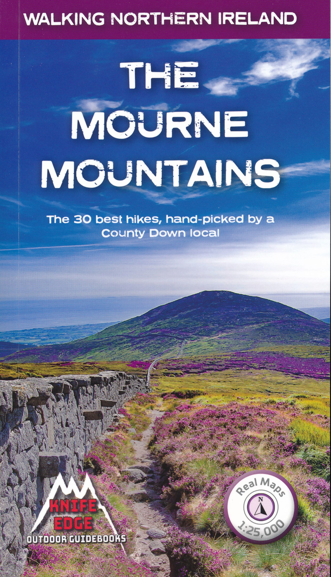
- The Mourne Mountains
- The 30 best hikes, handpicked by a County Down local Read more
- Also available from:
- De Zwerver, Netherlands
- Stanfords, United Kingdom
De Zwerver
Netherlands
2019
Netherlands
2019
- Wandelgids The Mourne Mountains | Knife Edge Outdoor
- The 30 best hikes, handpicked by a County Down local Read more

Stanfords
United Kingdom
2019
United Kingdom
2019
- The Mourne Mountains: The 30 best hikes, handpicked by a County Down local
- The only guidebook for the Mourne Mountains written by a County Down local hiker: 30 handpicked routes.The only guidebook for the Mourne Mountains with Real 1:25,000 Maps: this makes navigation easy and saves you money: no need to carry additional maps.Also includes:Game of Thrones film locationsNumbered waypoints linking maps to textQuick... Read more
Karten

The Book Depository
United Kingdom
2018
United Kingdom
2018
- Ben Nevis and Glen Coe
- Waterproof mountain map of Ben Nevis & Glen Coe from Harvey at 1:40,000, with a geological map of the region on the reverse, an enlargement of Ben Nevis' summit, and advice on navigating the region safely.MAIN MAP: Topography is shown through clear altitude shading, spot heights, contours at 15m intervals, and index contours at 75m intervals. A... Read more
- Also available from:
- De Zwerver, Netherlands
- Stanfords, United Kingdom

De Zwerver
Netherlands
2018
Netherlands
2018
- Wandelkaart Ben Nevis & Glen Coe | Harvey Maps
- Waterproof mountain map of Ben Nevis & Glen Coe from Harvey at 1:40,000, with a geological map of the region on the reverse, an enlargement of Ben Nevis' summit, and advice on navigating the region safely.MAIN MAP: Topography is shown through clear altitude shading, spot heights, contours at 15m intervals, and index contours at 75m intervals. A... Read more

Stanfords
United Kingdom
2018
United Kingdom
2018
- Ben Nevis & Glen Coe Harvey British Mountain Map XT40
- Waterproof mountain map of Ben Nevis & Glen Coe from Harvey at 1:40,000, with a geological map of the region on the reverse, an enlargement of Ben Nevis` summit, and advice on navigating the region safely.*MAIN MAP:* Topography is shown through clear altitude shading, spot heights, contours at 15m intervals, and index contours at 75m intervals.... Read more

- Also available from:
- Stanfords, United Kingdom

Stanfords
United Kingdom
United Kingdom
- Delaware Water Gap NJ/PA
- Map No. 737, Delaware Water Gap between Pennsylvania and New Jersey at 1:40,000, in an extensive series of GPS compatible, contoured hiking maps of USA’s national and state parks or forests and other popular recreational areas. Cartography is based on the national topographic survey, with additional tourist information.The maps, with most... Read more

- Also available from:
- De Zwerver, Netherlands
- Stanfords, United Kingdom


Stanfords
United Kingdom
United Kingdom
- Glocknergruppe - Matrei - Kals - Heiligenblut Tabacco 076
- This Tabacco topographic map at 1:25,000 (1cm = 250m) covers the Alta Via routes, as well as the Via Ferrata where you get further than the ordinary walker with the help of steel ladders. Additional information includes: symbols to indicate 6 different types of accommodation from mountain hut, hotel to camping site. As well as information on... Read more

De Zwerver
Netherlands
2019
Netherlands
2019
- Reisgids Iceland Road Guide | Vegahandbokin
- Iceland Road Guide from Vegahandbókin, an exceptionally comprehensive, 605-page guide with region-by-region descriptions of sites accompanied by road maps and street plans, plus a separate road atlas section covering the whole country at 1:500,000 and information on a wide variety of tourism relating topics to help the user get the best of... Read more
- Also available from:
- Stanfords, United Kingdom

Stanfords
United Kingdom
2019
United Kingdom
2019
- Iceland Road Guide
- Iceland Road Guide from Vegahandbókin, an exceptionally comprehensive, 605-page guide with region-by-region descriptions of sites accompanied by road maps and street plans, plus a separate road atlas section covering the whole country at 1:500,000 and information on a wide variety of tourism relating topics to help the user get the best of... Read more

Stanfords
United Kingdom
United Kingdom
- Europe High 5 Edition Camping Atlas
- The first physical atlas with direct access to useful additional information from the InternetThe entirety of Europe on 432 pages in a scale of 1:800,000 clearly presented, including lots more travel information:- Road Companion (roadmaps) in a scale of 1:800,000, inclusive of the High 5 - Edition app technology for calling up additional travel... Read more

Stanfords
United Kingdom
2021
United Kingdom
2021
- Belgium NGI Long-Distance Trails Map
- Belgium: Long-distance Footpaths Map at 1:300,000 from Nationaal Geografisch Instituut/Institut Géographique National, the country’s national survey organization, showing the network of the waymarked long-distance GR routes.The map uses as its base a road map of the country, with an overprint highlighting the network of Belgium’s long-distance... Read more

Stanfords
United Kingdom
United Kingdom
- Chainpur
- Chainpur, sheet no. 2981-05, in the topographic survey of Nepal at 1:50,000 published by the Nepali Government in the late 1990s and early 2000s and produced from remote sensing data by Finnish cartographers as part of that country’s international aid program. The maps cover 15’ x 15’ quadrangles.IMPORTANT – PLEASE NOTE BEFORE ORDERING:... Read more
Stanfords
United Kingdom
United Kingdom
- Lamjun Himal
- Lamjun Himal, sheet no. 2884-09, in the topographic survey of Nepal at 1:50,000 published by the Nepali Government in the late 1990s and early 2000s and produced from remote sensing data by Finnish cartographers as part of that country’s international aid program. The maps cover 15’ x 15’ quadrangles.IMPORTANT – PLEASE NOTE BEFORE ORDERING:... Read more
Stanfords
United Kingdom
United Kingdom
- Taplejung
- Taplejung, sheet no. 2787-11, in the topographic survey of Nepal at 1:50,000 published by the Nepali Government in the late 1990s and early 2000s and produced from remote sensing data by Finnish cartographers as part of that country’s international aid program. The maps cover 15’ x 15’ quadrangles.IMPORTANT – PLEASE NOTE BEFORE ORDERING:... Read more
Stanfords
United Kingdom
United Kingdom
- Tinje
- Tinje, sheet no. 2983-10, in the topographic survey of Nepal at 1:50,000 published by the Nepali Government in the late 1990s and early 2000s and produced from remote sensing data by Finnish cartographers as part of that country’s international aid program. The maps cover 15’ x 15’ quadrangles.IMPORTANT – PLEASE NOTE BEFORE ORDERING:... Read more
Stanfords
United Kingdom
United Kingdom
- Lukla - Salleri
- Lukla - Salleri, sheet no. 2786-07, in the topographic survey of Nepal at 1:50,000 published by the Nepali Government in the late 1990s and early 2000s and produced from remote sensing data by Finnish cartographers as part of that country’s international aid program. The maps cover 15’ x 15’ quadrangles.IMPORTANT – PLEASE NOTE BEFORE ORDERING:... Read more
Stanfords
United Kingdom
United Kingdom
- Takagau
- Takagau, sheet no. 2882-08, in the topographic survey of Nepal at 1:50,000 published by the Nepali Government in the late 1990s and early 2000s and produced from remote sensing data by Finnish cartographers as part of that country’s international aid program. The maps cover 15’ x 15’ quadrangles.IMPORTANT – PLEASE NOTE BEFORE ORDERING:... Read more
Stanfords
United Kingdom
United Kingdom
- Yanma
- Yamna, sheet no. 2787-04, in the topographic survey of Nepal at 1:50,000 published by the Nepali Government in the late 1990s and early 2000s and produced from remote sensing data by Finnish cartographers as part of that country’s international aid program. The maps cover 15’ x 15’ quadrangles.IMPORTANT – PLEASE NOTE BEFORE ORDERING:... Read more
Stanfords
United Kingdom
United Kingdom
- Rachuli
- Rachuli, sheet no. 2981-16, in the topographic survey of Nepal at 1:50,000 published by the Nepali Government in the late 1990s and early 2000s and produced from remote sensing data by Finnish cartographers as part of that country’s international aid program. The maps cover 15’ x 15’ quadrangles.IMPORTANT – PLEASE NOTE BEFORE ORDERING:... Read more
Stanfords
United Kingdom
United Kingdom
- Tiptala Bhañjyan
- Tiptala Bhanjyan, sheet no. 2787-03, in the topographic survey of Nepal at 1:50,000 published by the Nepali Government in the late 1990s and early 2000s and produced from remote sensing data by Finnish cartographers as part of that country’s international aid program. The maps cover 15’ x 15’ quadrangles.IMPORTANT – PLEASE NOTE BEFORE ORDERING:... Read more