
GR5
Beschreibung
- Name GR5 (GR5)
- Länge von Wanderweg 2,600 km, 1,616 Meilen
- Länge in Tagen 130 Tage
- Anfang von Wanderweg Bergen op Zoom (Nl)
- Ende von Wanderweg Nice (F)
- Traildino Schwierigkeit MW, Mittelschwere Wanderung mit Rucksack
- Schwierigkeitsgrad Berg- und Alpinwanderung T1, Wandern


Northsea - Riviera, three months
The GR5 is one of the most popular long distance hikes in Europe. And with reasons: the trail connects the North Sea with the Mediterranean and crosses some of the best and most varied mountain ranges of the continent. If you want, you can continue the GR5 north into Great Brittain: the E2.
Along this trail, friendships were coined and hiking clubs were born... Not surprisingly, a lot of information can be found on the world wide web.
The trail starts in the Netherlands, Bergen op Zoom. Soon the path enters Flanders and its sandy grounds and typical villages. The GR5 again enters the Netherlands, the old and interesting city of Maastricht. Next is the Ardennes region of Belgium, the romantic and forested hills with its grey houses and farms. Third country is Luxembourg. The path follows the border with Germany, along the meandering river Moselle and its castles.
In France the GR5 explores the Vosges, then the Jura, sometimes crossing the border with Switzerland, and finally, after crossing the lake of Geneva by ferry, it follows the length of the Alps. Highlight here is the Mont Blanc. But also the Vanoise, Écrins, Queyras and Mercantour. The trail ends in Nice, good place for a refreshing bath and good meal before returning home.
Many hikers made a life experience of this hike, often returning year after year to tag another section on the record. Nowadays the pilgrimage to Saint James of Compostela is probably more popular, highlighting the spiritual needs people probably have.
Karte


Links
Fakten
Berichte
Führer und Karten
Übernachtung
Organisationen
Reisebüros
GPS
Sonstiges
Bücher

United Kingdom
2018
- The GR5 Trail - Benelux and Lorraine
- The North Sea to Schirmeck in the Vosges mountains Read more
- Also available from:
- De Zwerver, Netherlands

Netherlands
2018
- Wandelgids The GR5 Trail Benelux and Lorraine | Cicerone
- Guidebook to walking the northern section of the GR5 - 1000km starting in Hoek van Holland and passing through the Netherlands, Belgium, Luxembourg and Lorraine to Schirmeck in France. A long-distance route covering a variety of cultures and landscapes. The full GR5 from the North Sea to the Mediterranean is one of the world's greatest trails. Read more


United Kingdom
2022
- Also available from:
- De Zwerver, Netherlands


- Also available from:
- De Zwerver, Netherlands

Netherlands
2021


Netherlands
2021

Netherlands
2021
- Wandelgids 265 Vogesen - Durchquerung: GR53 GR5 | Rother Bergverlag
- In 37 etappes over de Lange Astands Wandelingen GR 53, GR 5 en GR 531 van Wissembourg naar Giromagny en Masevaux door de prachtige Vogezen. Goed alternatief voor de langverwachte maar nog steeds niet uitgekomen Crete des Vosges wandelgids van FFRP. Duitse samenvatting: Die Vogesen sind nicht nur eines der urwüchsigsten Mittelgebirge in unseren... Read more

Netherlands
2009
- Wandelgids GR 5 Mer Du Nord-Mediterrannee Noordzee - Middellandse Zee deel Ardennen (Maastricht - Diekirch ) | GR Sentiers
- LET OP: deze wandelgids van dit deel van de GR5 is alleen nog maar in het Frans leverbaar. De Nederlandstalige versie is geheel uitverkocht, niet meer te bestellen en er komt naar alle waarschijnlijkheid geen nieuwe versie in het Nederlands! Uitstekende routegids met gedetailleerde kaarten en een routebeschrijving. Fout lopen wordt op deze... Read more

Netherlands
2017
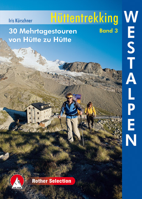
- Wandelgids Huttentochten - Hüttentrekking Westalpen Frankreich - Italien Band 3 | Rother Bergverlag
- Wild und urtümlich, so präsentiert sich das westliche Drittel des Alpenbogens. Viele Ortschaften dort sind stark von Abwanderung betroffen, sodass man nicht selten auf Geisterdörfer trifft, in denen nur noch ein paar Alte leben. Weitwanderrouten wie der GR 5 und die GTA, die Grande Traversata delle Alpi, spannende Höhenwege über aussichtsreiche... Read more


Netherlands
2021


Netherlands
2014
- Wandelgids 901 Tours et traversées dans l'Ain GR9, GR9A, GR59 | FFRP
- Guide FFRandonnée Tours et Traversée dans l'ain. GR 59, 9, 9A. Etangs de la Dombes, monts et cluses du Revermont ou bocages de la Bresse. Plus de 50 jours de randonnée.Depuis les Monts du Jura, du Revermont ou du Bugey, ces itinéraires en boucle ou en ligne offrent aux randonneurs des vues imprenables. voici à l'est le Mont Blanc et les... Read more
- Also available from:
- Stanfords, United Kingdom

United Kingdom
2014
- GR59/GR9/GRP: Tours et Traversées de l`Ain FFRP Topo-guide No. 901
- Tours et Traversées de l`Ain, FFRP topoguide, Ref. No. 901, covering in all 949km of hiking trails in the French Jura between Lons-le-Saunier and the confluence of the Ain and the Rhône, including sections of GR 5, 9 and 9A. Current edition of this title was published in June 2014.ABOUT THE FFRP (Fédération française de la randonnée pédestre)... Read more

Karten

- Also available from:
- De Zwerver, Netherlands


Netherlands
2014
- Wandelkaart 07 Mercantour & Alpi-Maritieme | Didier Richard
- Mercantour National Park and the Maritime Alps on a large, double-sided, contoured and GPS compatible map from Editions Didier Richard highlighting local walking trails and long-distance hiking routes including the GR5. Coverage extends from well north of Col de Larch to Sospel, Levens and Roquestéron in the mountains north of the French... Read more
- Also available from:
- Stanfords, United Kingdom

United Kingdom
2014
- Mercantour & Alpi-Marittime Didier Richard 07
- Mercantour National Park and the Maritime Alps on a large, double-sided, contoured and GPS compatible map from Editions Didier Richard highlighting local walking trails and long-distance hiking routes including the GR5. Coverage extends from well north of Col de Larch to Sospel, Levens and Roquestéron in the mountains north of the French... Read more


Netherlands
2016
- Wandelkaart 04 Vanoise - Beaufortain | Didier Richard
- Vanoise National Park and the Beaufortain Massif in the French Alps at 1:60,000 on a contoured and GPS compatible map from Didier Richard with a base derived from IGN Read more
- Also available from:
- Stanfords, United Kingdom

United Kingdom
2016
- Vanoise National Park - Beaufortain Didier Richard 04
- Vanoise National Park and the Beaufortain Massif in the French Alps at 1:60,000 on a contoured and GPS compatible map from Didier Richard with a base derived from IGN’s topographic survey, highlighting both local hiking routes and the GR network of long-distance paths, gîtes and mountain refuges, interesting natural and cultural sites, etc. The... Read more


Netherlands
- Wandelkaart 05 Outdoorkarte FR Elsass - Colmar - Sélestat - Elzas | Kümmerly & Frey
- The central part of Alsace around Colmar and Sélestat on a GPS compatible, double-sided map at 1:50,000 from Kümmerly+Frey printed on sturdy, waterproof and tear-resistant synthetic paper; contoured, with hiking and cycling routes, sites for other recreational activities, various accommodation options, restaurants and ferme-auberge locations,... Read more
- Also available from:
- Stanfords, United Kingdom

United Kingdom
- Alsace - Colmar - Sélestat - Freiburg im Breisgau - Lahr K+F Outdoor Map 5
- The central part of Alsace around Colmar and Sélestat on a GPS compatible, double-sided map at 1:50,000 from Kümmerly+Frey printed on sturdy, waterproof and tear-resistant synthetic paper; contoured, with hiking and cycling routes, sites for other recreational activities, various accommodation options, restaurants and ferme-auberge locations,... Read more


Netherlands
- Wandelkaart 07 Outdoorkarte FR Elsass, Vogesen - Alsace, Strasbourg Elzas - Vogezen | Kümmerly & Frey
- The central part of Alsace around Strasbourg and Saverne on a GPS compatible, double-sided map at 1:50,000 from K Read more
- Also available from:
- Stanfords, United Kingdom

United Kingdom
- Alsace - Strasbourg - Saverne - Barr - Offenburg K+F Outdoor Map 7
- The central part of Alsace around Strasbourg and Saverne on a GPS compatible, double-sided map at 1:50,000 from Kümmerly+Frey printed on sturdy, waterproof and tear-resistant synthetic paper; contoured, with hiking and cycling routes, sites for other recreational activities, various accommodation options, restaurants and ferme-auberge... Read more

United Kingdom
- Luxembourg South
- One of two topographic survey maps of Luxembourg at 1:50,000, with contours at 10-metres intervals and additional relief shading. An overprint highlights long-distance footpaths, including the GR5 (E-2), cycle routes, and various places of interest, including campsites. The map covers an area of approximately 53 x 43 km / 33 x 27 miles. Map... Read more

United Kingdom
- Autour du Thabor: Modane - Bardonecchia - Briançon
- Mont Thabor area at 1:50,000 on a contoured and GPS compatible map from Editions Didier Richard in their series of walking maps of French Alps and other popular hiking regions of south-eastern France. Coverage extends from Modane in the north to Briançon in the south-east, and west to Valloire.The base map with cartography from the IGN has... Read more

United Kingdom
- Alsace - Mulhouse - Basel - Altkirch K+F Outdoor Map 2
- The southern part of Alsace around Mulhouse and Guebwiller on a GPS compatible, double-sided map at 1:50,000 from Kümmerly+Frey printed on sturdy, waterproof and tear-resistant synthetic paper; contoured, with hiking and cycling routes, sites for other recreational activities, various accommodation options, restaurants and ferme-auberge... Read more

United Kingdom
- Luxembourg North
- One of two topographic survey maps of Luxembourg at 1:50,000, with contours at 10-metres intervals and additional relief shading. An overprint highlights long-distance footpaths, including the GR5 (E-2), cycle routes, and various places of interest, including campsites. The map covers an area of approximately 53 x 43 km / 33 x 27 miles. Map... Read more

United Kingdom
- Nice - Menton - PN du Mercantour IGN TOP100 165
- Discover the new double-sided laminated edition of TOP100 road maps of France from the Institut Géographique National (IGN); exceptionally detailed, contoured road maps which include the cycle paths and greenways of the AF3V (French Association for the Development of Cycle Paths and Greenways), ideal for exploring the French countryside by car,... Read more