
Grand Combin
Beschreibung
Karte

Wanderwege Region
Links
Fakten
Berichte
Führer und Karten
Übernachtung
Organisationen
Reisebüros
GPS
Sonstiges
Bücher

The Book Depository
United Kingdom
2019
United Kingdom
2019
- Walkers's Haute Route: Chamonix to Zermatt
- The epic journey between Mont Blanc and the Matterhorn Read more
- Also available from:
- De Zwerver, Netherlands
- Stanfords, United Kingdom

De Zwerver
Netherlands
2019
Netherlands
2019
- Wandelgids Walker's Haute Route: Chamonix to Zermatt | Knife Edge Outdoor
- The epic journey between Mont Blanc and the Matterhorn Read more

Stanfords
United Kingdom
2019
United Kingdom
2019
- Walkers`s Haute Route: Chamonix to Zermatt: The epic journey between Mont Blanc and the Matterhorn
- An incredible trek between the two most famous mountain towns in the Alps. Travelling from Chamonix in France to Zermatt in Switzerland, you will start at Mont Blanc and finish at the Matterhorn. On the way, pass the largest collection of snowy 4000m summits in the Alps: Mont Blanc, Grand Combin, the Weisshorn, the Zinalrothorn, the Dom, the... Read more
De Zwerver
Netherlands
2018
Netherlands
2018
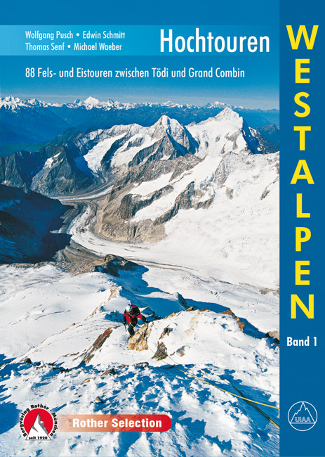
- Klimgids - Klettersteiggids Hochtouren Westalpen | Rother Bergverlag
- 88 Fels- und Eistouren zwischen Tödi und Grand Combin Rother Selection. 4., aktualisierte Auflage. Read more

De Zwerver
Netherlands
2013
Netherlands
2013
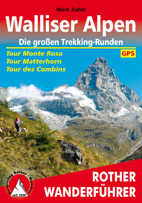
- Wandelgids Walliser Alpen | Rother Bergverlag
- Uitstekende wandelgids met een groot aantal dagtochten in dal en hooggebergte. Met praktische informatie en beperkt kaartmateriaal! Wandelingen in verschillende zwaarte weergegeven in rood/blauw/zwart. Nirgends ballen sich solch großartige hochalpine Impressionen, so viele Viertausender auf engem Raum wie in den Walliser Alpen. Drei große... Read more
- Also available from:
- Bol.com, Netherlands
- Bol.com, Belgium
Bol.com
Netherlands
2013
Netherlands
2013
- Walliser Alpen. Die gro en Trekking-Runden
- Uitstekende wandelgids met een groot aantal dagtochten in dal en hooggebergte. Met praktische informatie en beperkt kaartmateriaal! Wandelingen in verschillende zwaarte weergegeven in rood/blauw/zwart. Nirgends ballen sich solch großartige hochalpine Impressionen, so viele Viertausender auf engem Raum wie in den Walliser Alpen. Drei große... Read more
Bol.com
Belgium
2013
Belgium
2013
- Walliser Alpen. Die gro en Trekking-Runden
- Uitstekende wandelgids met een groot aantal dagtochten in dal en hooggebergte. Met praktische informatie en beperkt kaartmateriaal! Wandelingen in verschillende zwaarte weergegeven in rood/blauw/zwart. Nirgends ballen sich solch großartige hochalpine Impressionen, so viele Viertausender auf engem Raum wie in den Walliser Alpen. Drei große... Read more

Stanfords
United Kingdom
2017
United Kingdom
2017
- The Swiss Alpine Pass Route - via Alpina Route 1: Trekking East to West Across Switzerland
- This guidebook presents the stunning Alpine Pass Route, now fully waymarked as Via Alpina 1. The 360km trail traverses Switzerland from east to west, from Sargans near the Liechtenstein border to Montreux on Lac Leman (Lake Geneva). Crossing sixteen Alpine passes, it showcases some of the country`s most breathtaking mountain landscapes,... Read more
- Also available from:
- Bol.com, Netherlands
- Bol.com, Belgium

Bol.com
Netherlands
2017
Netherlands
2017
- The Swiss alpine pass route - Via Alpina route 1
- This guidebook presents the stunning Alpine Pass Route, now fully waymarked as Via Alpina 1. The 360km trail traverses Switzerland from east to west, from Sargans near the Liechtenstein border to Montreux on Lac Léman (Lake Geneva). Crossing sixteen Alpine passes, it showcases some of the country's most breathtaking mountain landscapes,... Read more
Bol.com
Belgium
2017
Belgium
2017
- The Swiss alpine pass route - Via Alpina route 1
- This guidebook presents the stunning Alpine Pass Route, now fully waymarked as Via Alpina 1. The 360km trail traverses Switzerland from east to west, from Sargans near the Liechtenstein border to Montreux on Lac Léman (Lake Geneva). Crossing sixteen Alpine passes, it showcases some of the country's most breathtaking mountain landscapes,... Read more

Bol.com
Netherlands
Netherlands
- Mountain Days at Home and Abroad
- 'Mountain Days at Home and Abroad' is a lively account of the author's adventures in the mountains over a period of some 40 years, starting from the early days when he took part in annual mountain challenges and volunteered as an instructor on various Hill Walking and Climbing courses run by the Scouts from the old railway station at... Read more
- Also available from:
- Bol.com, Belgium
Bol.com
Belgium
Belgium
- Mountain Days at Home and Abroad
- 'Mountain Days at Home and Abroad' is a lively account of the author's adventures in the mountains over a period of some 40 years, starting from the early days when he took part in annual mountain challenges and volunteered as an instructor on various Hill Walking and Climbing courses run by the Scouts from the old railway station at... Read more
Bol.com
Netherlands
Netherlands
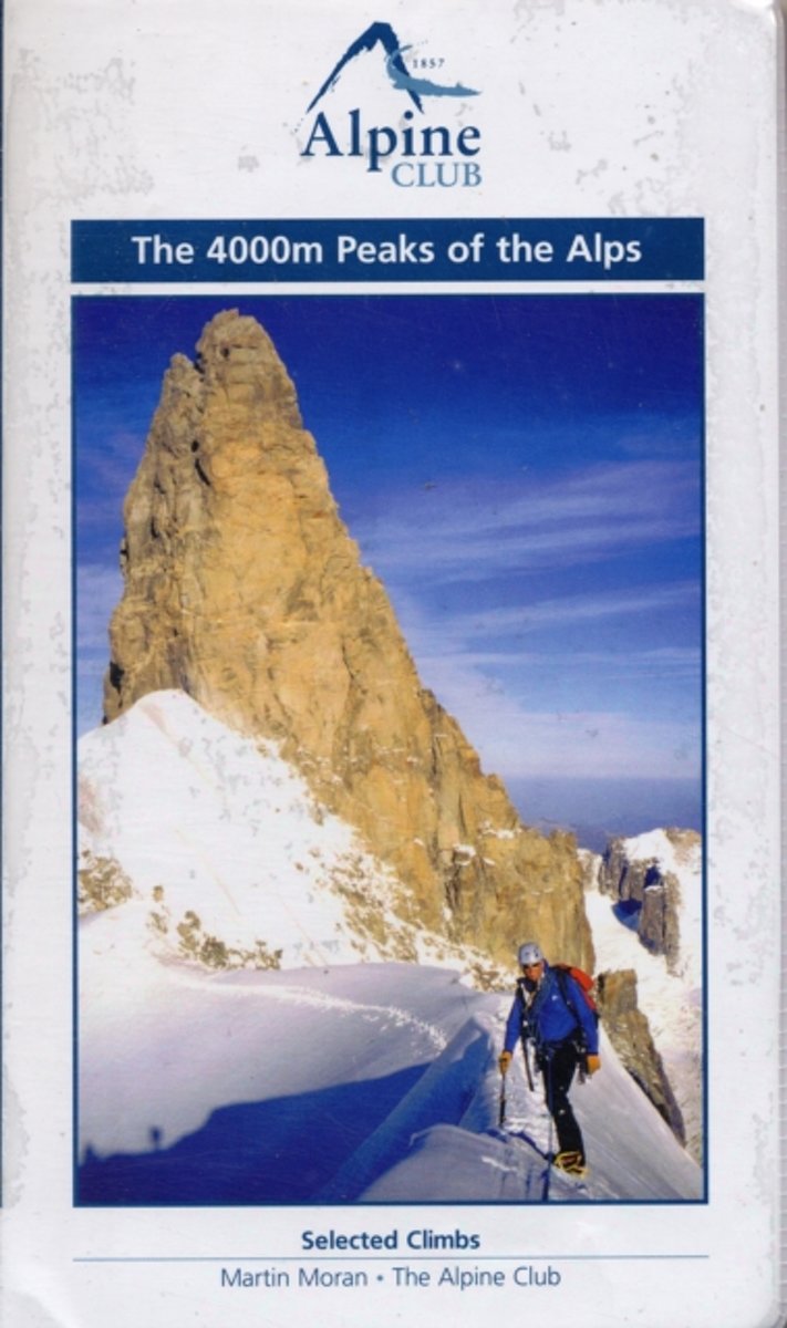
- The 4000m Peaks of the Alps - Selected Climbs
- The 4000m Peaks of the Alps provides a practical companion guide to the Alpine 4000ers with detailed description of every worthwhile route from Facile (F) to Difficile (sup) (D+/TD-). As well as the 50 major mountains, every significant subsidiary top is visited by one or more route. In total over 230 routes are described, ranging from... Read more
- Also available from:
- Bol.com, Belgium
Bol.com
Belgium
Belgium
- The 4000m Peaks of the Alps - Selected Climbs
- The 4000m Peaks of the Alps provides a practical companion guide to the Alpine 4000ers with detailed description of every worthwhile route from Facile (F) to Difficile (sup) (D+/TD-). As well as the 50 major mountains, every significant subsidiary top is visited by one or more route. In total over 230 routes are described, ranging from... Read more
Bol.com
Netherlands
Netherlands
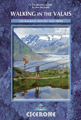
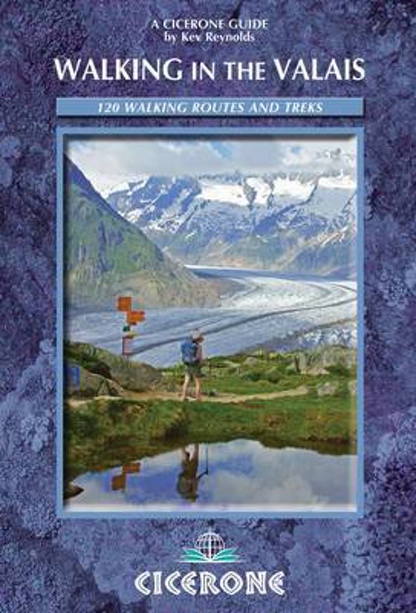
- Walking In The Valais
- The Pennine Alps in the Valais region of Switzerland contain more 4000m peaks than anywhere else in Western Europe and some of the greats: the Matterhorn, Monte Rosa, Dent Blanche and Grand Combin, all surrounded by idyllic valleys and hillsides dotted with chalets, hay barns and hardy little alpine flowers as well as pristine snowfields and... Read more
- Also available from:
- Bol.com, Belgium
Bol.com
Belgium
Belgium
- Walking In The Valais
- The Pennine Alps in the Valais region of Switzerland contain more 4000m peaks than anywhere else in Western Europe and some of the greats: the Matterhorn, Monte Rosa, Dent Blanche and Grand Combin, all surrounded by idyllic valleys and hillsides dotted with chalets, hay barns and hardy little alpine flowers as well as pristine snowfields and... Read more

- Also available from:
- De Zwerver, Netherlands
- Bol.com, Netherlands
- Bol.com, Belgium
De Zwerver
Netherlands
2014
Netherlands
2014
- Wandelgids Walks In The Valais | Cicerone
- Comprehensive guidebook to the Valais, Switzerland, describing 111 day walks and 10 multi-day tours. Some of Europe's most dramatic mountains are found here, including the Matterhorn, Monte Rosa, Dent Blanche and Grand Combin. From easy valley walks to harder treks across rugged passes - routes for all abilities. Read more
Bol.com
Netherlands
2014
Netherlands
2014
- Walking in the Valais
- The Pennine Alps in the Valais region of Switzerland contain more 4000m peaks than anywhere else in Western Europe and some of the greats: the Matterhorn, Monte Rosa, Dent Blanche and Grand Combin, all surrounded by idyllic valleys and hillsides dotted with chalets, hay barns and hardy little alpine flowers as well as pristine snowfields and... Read more
Bol.com
Belgium
2014
Belgium
2014
- Walking in the Valais
- The Pennine Alps in the Valais region of Switzerland contain more 4000m peaks than anywhere else in Western Europe and some of the greats: the Matterhorn, Monte Rosa, Dent Blanche and Grand Combin, all surrounded by idyllic valleys and hillsides dotted with chalets, hay barns and hardy little alpine flowers as well as pristine snowfields and... Read more

The Book Depository
United Kingdom
2011
United Kingdom
2011
- Trekking in the Alps
- An inspirational guidebook to 20 classic treks in the Alps. As well as introducing new hiking areas in the Alps, classics such as the Tour of Mont Blanc, and Chamonix to Zermatt are included. Trekking in the Alps is immensely satisfying, and this book celebrates the rich and scenic diversity for which this great mountain range is renowned. Read more
- Also available from:
- De Zwerver, Netherlands
- Bol.com, Netherlands
- Bol.com, Belgium

De Zwerver
Netherlands
2019
Netherlands
2019
- Wandelgids Trekking in the Alps | Cicerone
- An inspirational guidebook to 20 classic treks in the Alps. As well as introducing new hiking areas in the Alps, classics such as the Tour of Mont Blanc, and Chamonix to Zermatt are included. Trekking in the Alps is immensely satisfying, and this book celebrates the rich and scenic diversity for which this great mountain range is renowned. Read more

Bol.com
Netherlands
2011
Netherlands
2011
- Trekking in the Alps
- An inspirational guide to the delights of Alpine multi-day hikes. With 20 hikes described, including classics such as the Tour of Mont Blanc and the Tour of the Vanoise as well as new multi-day routes like the Traverse of the Slovenian Alps, this guide celebrates the rich scenic diversity for which the Alps are renowned.The eight talented... Read more
Bol.com
Belgium
2011
Belgium
2011
- Trekking in the Alps
- An inspirational guide to the delights of Alpine multi-day hikes. With 20 hikes described, including classics such as the Tour of Mont Blanc and the Tour of the Vanoise as well as new multi-day routes like the Traverse of the Slovenian Alps, this guide celebrates the rich scenic diversity for which the Alps are renowned.The eight talented... Read more
Karten
De Zwerver
Netherlands
Netherlands
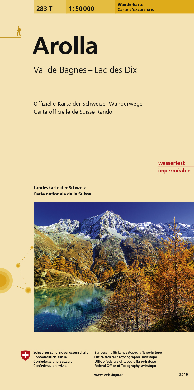
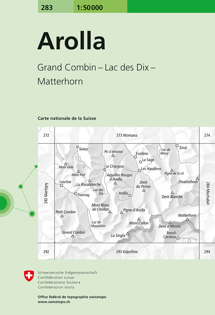
- Wandelkaart 283T Arolla | Swisstopo
- Arolla area, map No. 283T, at 1:50,000 in a special hiking edition of the country Read more
- Also available from:
- Stanfords, United Kingdom

Stanfords
United Kingdom
United Kingdom
- Arolla Swisstopo Hiking 283T
- Arolla area, map No. 283T, at 1:50,000 in a special hiking edition of the country’s topographic survey, published by Swisstopo in cooperation with the Swiss Hiking Federation. The map covers the peaks from the Matterhorn to Grand Combin, and the southern part of Val d’Herens with Evolène and La Forclaz.Cartography, identical to the standard... Read more
De Zwerver
Netherlands
2011
Netherlands
2011
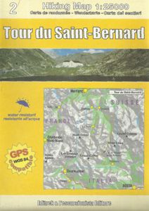
- Wandelkaart TRK02 Tour du Saint-Bernard | L'Escursionista editore
- Tour of Saint-Bernard long-distance hiking route presented on a waterproof and tear-resistant, contoured and GPS compatible map at 1:25,000 published jointly by L Read more
- Also available from:
- Stanfords, United Kingdom

Stanfords
United Kingdom
2011
United Kingdom
2011
- Tour of Saint-Bernard L`Escursionista Editore Map-Guide
- Tour of Saint-Bernard long-distance hiking route presented on a waterproof and tear-resistant, contoured and GPS compatible map at 1:25,000 published jointly by L’Escursionista Editore and Editrek, plus a separate multilingual guide booklet with stage by stage descriptions and other tourist information.Contour interval is 25m and the map has... Read more
De Zwerver
Netherlands
Netherlands
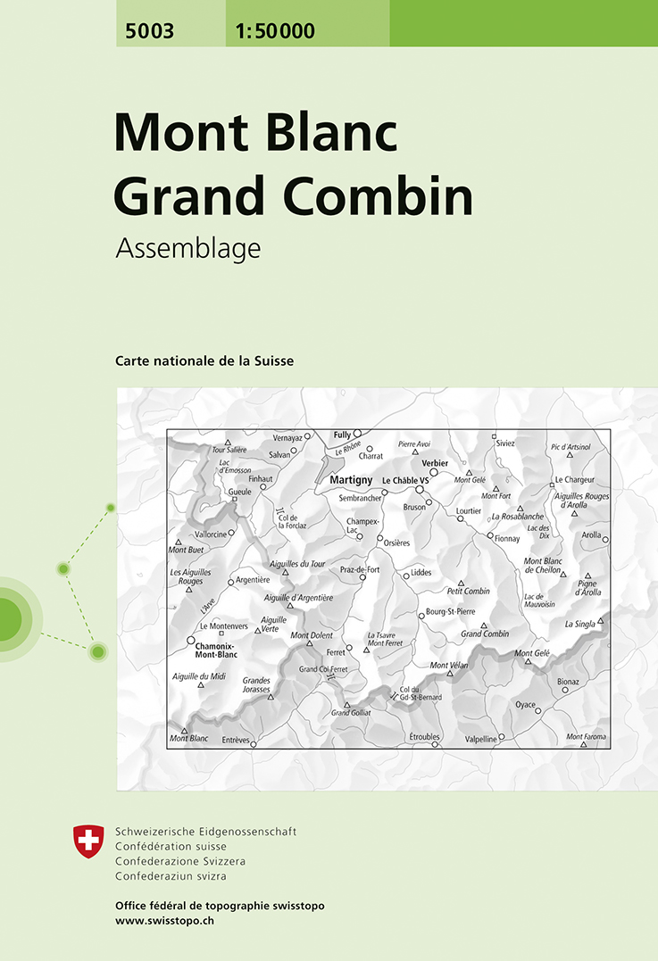
- Wandelkaart - Topografische kaart 5003 Mont Blanc Grand Combin | Swisstopo
- Mont Blanc - Grand Combin area, map No. 5003, in the standard topographic survey of Switzerland at 1:50,000 from Swisstopo, i.e. without the special overprint highlighting walking trails, local bus stops, etc, presented in Swisstopo Read more
- Also available from:
- Stanfords, United Kingdom

Stanfords
United Kingdom
United Kingdom
- Mont Blanc - Grand Combin Swisstopo 5003
- Mont Blanc - Grand Combin area, map No. 5003, in the standard topographic survey of Switzerland at 1:50,000 from Swisstopo, i.e. without the special overprint highlighting walking trails, local bus stops, etc, presented in Swisstopo’s hiking editions of the 50K survey. Coverage extends from Chamonix and the Mont Blanc massif eastwards to Arolla... Read more
De Zwerver
Netherlands
Netherlands
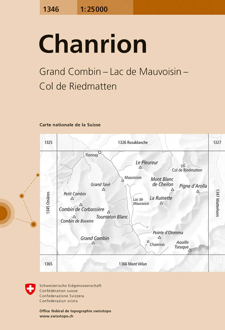
- Wandelkaart - Topografische kaart 1346 Chanrion | Swisstopo
- Map No. 1346, Chanrion, in the topographic survey of Switzerland at 1:25,000 from Bundesamt f Read more
- Also available from:
- Stanfords, United Kingdom

Stanfords
United Kingdom
United Kingdom
- Chanrion Swisstopo 1346
- Map No. 1346, Chanrion, in the topographic survey of Switzerland at 1:25,000 from Bundesamt für Landestopographie (swisstopo), covering the whole country on 247 small format sheets, with special larger maps published for popular regions including some titles now available in hiking versions.Highly regarded for their superb use of graphic relief... Read more
De Zwerver
Netherlands
Netherlands
- Wandelkaart - Topografische kaart 283 Arolla | Swisstopo
- Arolla, map No. 283, in the standard topographic survey of Switzerland at 1:50,000 from Swisstopo, i.e. without the special overprint highlighting walking trails, local bus stops, etc, presented in Swisstopo Read more
- Also available from:
- Stanfords, United Kingdom

Stanfords
United Kingdom
United Kingdom
- Arolla Swisstopo 283
- Arolla, map No. 283, in the standard topographic survey of Switzerland at 1:50,000 from Swisstopo, i.e. without the special overprint highlighting walking trails, local bus stops, etc, presented in Swisstopo’s hiking editions of the 50K survey. The map covers the peaks from the Matterhorn to Grand Combin, and the southern part of Val d’Herens... Read more

Stanfords
United Kingdom
United Kingdom
- Montreux
- Montreux - Col du Pillon area at 1:50,000 in a series from Hallwag covering Switzerland’s popular hiking regions on light, waterproof and tear-resistant maps highlighting long-distance paths: the nine national routes plus special regional routes, as well as other local hiking trails.Cartography is similar to that used both in Hallwag’s hiking... Read more